Hurricane Ike 15 Years Later

An original post from 2018 that is reposted and changed.

It is hard to believe it has been 15 years since Hurricane Ike made landfall on Southeast Texas as a monsterous Category 2 hurricane in the early morning hours of September 13, 2008. Between the fifteen years a lot has happened since Ike. Before Ike came crashing in, Cyclone Nargis ravaged Burma (Myanmar) and claimed over 138,000 lives. Not too long after, there is the Sichuan Earthquake that claims nearly 88,000 lives. Ike made landfall seven years after the devastating 9/11 Terrorist Attacks, which destroyed the World Trade Center and claimed nearly 3,000 lives. Ike came three years after Hurricane Katrina, Rita, and Wilma ravaged the US Coast. Four years after the Indian Ocean Tsunami that ravaged Indonesia and Thailand.

After Ike, comes the collapse of Lehman Brothers during a severe recession. There is the deadly Haitian Earthquake that claims up to 316,000 lives and the Deep Horizon Oil Spill in 2010. Japan was hit by a deadly Tsunami that led to the Fukushima Nuclear Meltdown in 2011. Harvey came and flooded out Southeast Texas with heavy rain over a large area in 2017. Then comes COVID pandemic, which started in 2019, but did not get noticed until 2020. Ukraine and Sudan are currently mired in war.

Ike pelted Southeast Texas and Southwest Louisiana with hurricane force winds and heavy rain. Ike was the last hurricane to hit Texas prior to Harvey. Almost a nine year gap of no hurricanes hitting Texas, let alone a major hurricane. The last major hurricane to hit Texas prior to Harvey was Bret in 1999, which is 18 years.

Thunderstorms over Sudan that later became Ike.

What is the origin of Hurricane Ike? Ike started as a mesoscale convective system (MCS) that formed over Sudan on August 19th. Most tropical waves come from thunderstorms that form in the Northeast part of Africa. They are set off by the Intertropical Convergence Zone (ITCZ) or monsoon. The ITCZ is where there is thunderstorms from the clash of trade winds. These thunderstorms often provide beneficial rains in tropical and subtropical areas. The thunderstorms in ITCZ can break away and travel away. One of those thunderstorms from the ITCZ managed to do that. The MCS traveled over Africa and entered the Atlantic Ocean as a tropical wave on August 29th. The tropical wave traveled across with multiple vortices competing. One of them would win out as the thunderstorms in the tropical wave get better organized on September 1, 2008. It is upgraded to Tropical Depression #9. Later that day, it is named Ike as it travels over the open Atlantic. Tropical Storm Ike has to deal with wind shear in the upper level early in its life. The wind shear blows tops of thunderstorms, especially westerly wind shear. Since 2008 season is Neutral to La Nina, conditions are more favorable as there is less westerly wind shear. If 2008 was El Nino, there would be more westerly wind shear, which is why generally El Nino Atlantic Hurricane seasons see less storms. Wind shear generally kills tropical development. The higher the storm clouds are, the cooler it is. Higher storm clouds also mean they are more intense.

However, Ike gets a reprieve as the wind shear weakens and encounter warmer waters on September 3rd. This allows Ike to rapidly intensify into a major hurricane. By the next day, Ike becomes 2008’s strongest hurricane with 145 mph 126 knots 233 km/h winds and central pressure of 935 millibars. Ike’s strength did not last as it encountered wind shear on September 5th. The wind shear weaken Ike to Category 2 strength.

Hurricane Ike around its peak.

Ike is pushed southwards into more favorable areas due to upper level ridge to the north. Ike becomes a Category 4 hurricane as conditions are more favorable. As it goes westward, Ike made its first landfall on Turks and Caicos Islands as a Category 4 hurricane on the early morning hours of September 7th. The Turks and Caicos Islands are the first to feel Ike’s violent wrath in the form of strong winds, heavy rain, storm surge, and high waves. The South Caicos and Grand Turk take the brunt of Ike. Despite Ike’s fury, there are no reports of fatalities.

Damage in Grand Turk.

While Ike is ravaging the Turks and Caicos Islands, the outer bands of Ike are dumping heavy rain on Haiti and Dominican Republic, which have been ravaged by Fay, Gustav, and Hanna. The flooding from Ike claims 74 lives in Haiti and 2 in Dominican Republic. Prior to Ike, Tropical Storm Hanna ravaged Haiti and Dominican Republic with heavy rain that led to massive flooding. The flooding claims 529 lives in Haiti, while just one dies in Dominican Republic. Why did Haiti see more fatalities than Dominican Republic? The lack of trees in Haiti makes it even more vulnerable to mudslides from the mountains. The heavy rain causes deadly mudslides that destroys houses and kill people.

Stranded Cubans following Ike.

Once Ike passes Turks and Caicos Island, Ike heads for Cuba. The hurricane makes landfall on Cabo Lucrecia, Holguín Province, Cuba. Cuba is in a very rough ride with Ike as it traverses over the entire island nation. Cuba is being pelted by heavy rain, strong wind, high waves, and storm surge. Briefly, Ike goes over the water only to make a second landfall on Punta La Capitana, Pinar del Río, Cuba on September 8th as a Category 1 hurricane. Ike claims 7 lives in Cuba.

Ike near its secondary peak in Gulf of Mexico.

Once Ike exits Cuba, it is a large Category 1 hurricane. Ike traveling over all of Cuba caused the storm to expand as energy is spread out from land interaction. It also disrupted Ike’s core. Ike enters large area of warm water in the Gulf of Mexico and is getting close to the Loop Current, which is one of the warmest spot. Ike rapidly deepen from 963 to 944 millibars on the night of September 10th as it was over the Loop Current. However, the wind did not strengthen much, only from 80 to 100 mph 70 knots to 87 knots 128 km/h to 161 km/h. The reason is Ike is a very large hurricane with hurricane force winds extending up to 125 miles 109 nautical miles 201 kilometers from the eye. The pressure gradient is not tight due to its large size. Normally, an Atlantic hurricane with central pressure of 944 millibars is a Category 3 or 4 hurricane.

On September 11th, as America remembers and reflects the seventh anniversary of the 9/11 Terrorist Attacks, Southeast Texas is sunny and dry. The west side of a hurricane in the Northern Hemisphere is usually the “clean” side. It blows in dry and sinking air from the north. The nice sunny day is very deceptive as Ike is ever inching closer. Meanwhile in the Gulf of Mexico, Ike is generating massive waves that are heading towards the Texas and Louisiana. Ike continues across the Gulf of Mexico as a large Category 2 hurricane. Waves are coming ahead of Ike in coastal Texas. People are evacuating from coastal areas including Galveston. Some choose to stay behind. The outer cloud banks of Ike are over Southeast Texas as winds start to pick up. By the afternoon of September 12th, some coastal areas are getting squally weather from the feeder bands entering Texas.

By the night of September 12th, conditions have gotten much worse. Meanwhile in Houston area, it is still windy with occasionally light rain. As the night progresses, Ike is getting closer to landfall. The hurricane force winds enter Texas around the late hours of September 12th. Ike is getting stronger and developing a more organized eyewall. Ike now has a central pressure of 951 millibars and 110 mph 96 knots 177 km/h winds. Ike is a large hurricane with hurricane force winds extending up to 125 miles and tropical storm force winds extending up to 260 miles 226 nautical miles 418 kilometers.

Ike at landfall on Southeast Texas.
Highest wind gust possible based on multiplying by factor of 1.5.

By the early morning hours of September 13th, Houston area is seeing stronger winds and heavier rain. Power starts to go out throughout Southeast Texas as power lines are being knocked by the strong wind. The coastal areas are seeing storm surge getting higher and higher. Anyone who stayed behind in Galveston or Bolivar Peninsula are doomed by the massive storm surge. Ike makes landfall on the eastern end of Galveston Island at 2:10 AM Central Time. People who are staying behind in the coastal areas are wishing they had evacuated as they are surrounded by rising storm surge. Ike travels to the northwest towards Houston. By 4:00 AM, Ike is over Baytown, which is flooded by storm surge. A large area of Southeast Texas is getting hurricane force winds including all of Houston.

Highest sustained winds during Hurricane Ike.
Bolivar Peninsula following Ike.

By the time the Sun rises, Ike is still ravaging Southeast Texas despite the fact it has weakened to Category 1 hurricane. Ike remains a monsterous and very dangerous hurricane. Many areas are still seeing heavy rain and strong winds. The wind blow down numerous trees and damage many buildings and houses. There is widespread flooding reported throughout Southeast Texas. Bayous and rivers are overflowing from widespread heavy rain. Coastal areas had storm surge as high as 25 feet/7.6 meters. It is one of the highest storm surge recorded in America and highest in Texas. It exceeds Camille, but below Katrina. Bolivar Peninsula saw the highest storm surge as the whole area looked like if a nuclear bomb had exploded. Once it is all over, many buildings and houses are damaged or destroyed, while many trees are uprooted. Coastal areas are utterly gutted from the massive storm surge. Millions of people are out of power for days. A large area saw 6 to 12 inches/15.2 to 30.5 centimeters of rain from Ike.

The damage is not just limited to Texas. Louisiana also felt the brunt of Ike, especially in Southwestern Louisiana. It is the same area that had been ravaged by Hurricane Rita in 2005. Many areas are flooded by Ike. There is even flooding in New Iberia, which is in Central Louisiana. It shows that Ike’s massive size had a huge impact over a large area from Texas to Louisiana. This is despite the fact that they only got tropical storm force winds. It shows that large, but not so strong hurricane is very dangerous as it produces massive storm surge and high waves.

Thunderstorms ahead of a cold front in the early morning hours of September 14, 2008.

The following night, a cold front passes, which allows thunderstorms to form from moisture left by Ike. The storms dumped 5 to 8 inches/12.7 to 20.3 centimeters of rain. The heavy rain causes more flooding on top of what Ike dumped in Southeast Texas. Once the rain ended, many areas saw a two day total ranging from 10 to 20 inches/25.4 to 50.8 centimeters of rain. Meanwhile, the remnants of Ike continue to wreak havoc in the Midwest. Ohio see hurricane force gusts, which causes more power outages. The remains of Ike continue into Canada and dump heavy rain in Ontario and Quebec. A total of 112 people lost their life with 34 unaccounted for in America. Most of the deaths are in Texas, where 84 people died.

Rainfall total from September 12, 2008 to September 15, 2008.

So, how was 2008 like prior to Ike. The winter of 2007-2008 is La Nina, so it is warmer and drier. Despite the La Nina, there are storms. Spring of 2008 is mostly dry. There were days of pleasant weather in Spring 2008. Summer of 2008 is average in terms of temperature and rainfall. Texas first brush with a hurricane is Dolly, which affected South Texas. The outer bands of Dolly dump heavy rain in the Houston area. Not too long after Dolly came, Tropical Storm Edouard pays a visit to Houston area. It is a rather unremarkable tropical storm that dumps up to 6 inches of rain. Edouard moves inland and gives beneficial rains to drought ridden Central Texas.

NHC Hurricane Ike Report
NHC Hurricane Ike Advisory Report
Morphed Integrated Microwave Imagery at CIMSS (MIMIC)

Harvey: 5 Years Later

It is hard to believe, it has been five years since Hurricane Harvey made landfall near Port Aransas as a Category 4 hurricane with 130 mph winds. So much has happened since Harvey from COVID-19 Pandemic to Ukraine War. Harvey is the first major hurricane to make landfall on America since Wilma on October 24, 2005. Harvey made landfall on August 25, 2017. That is 43,23 days apart or 11 years, 10 months, 1 day or 142 months apart!

South Texas is hammered by strong wind, storm surge, and heavy rain. It packs a devastating punch. It is mainly along the coast in the Port Aransas area.

Port Aransas after Hurricane Harvey.
https://www.weather.gov/crp/hurricane_harvey

Once Harvey made landfall, it starts to weaken. Harvey is lingering over Texas. Large thunderstorms form near the center on the afternoon and evening of August 26, 2022. The large area of thunderstorms move toward Houston.

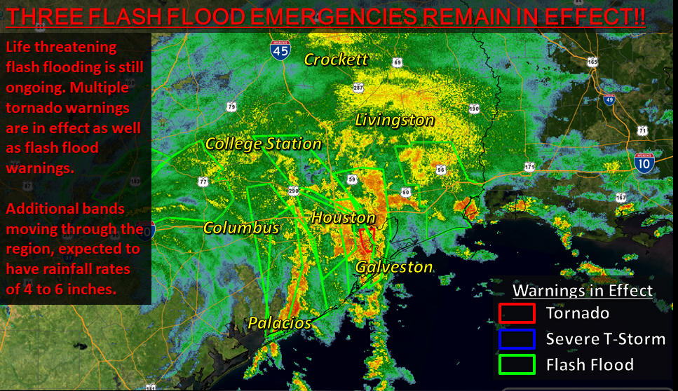
Doppler radar of Hurricane Harvey from National Weather Service.

The thunderstorms go over Houston area dumping heavy rain on the night of August 26, 2017 to the small hours of August 27, 2017. Heavy rain falls over and over on the Houston area.

NWS HGX Radar Showing Heavy Rain Falling Over the Area along with Active Warnings @ 4:07AM on 8/27/17
https://www.weather.gov/hgx/hurricaneharvey

Houston area is flooded. Large areas receive 15 to 35 inches of rain from Harvey! Many houses and buildings are flooded as bayous and rivers are overflowing from heavy rain. Streets and freeways are flooded.

Flooding near Downtown Houston.
https://www.weather.gov/hgx/hurricaneharvey

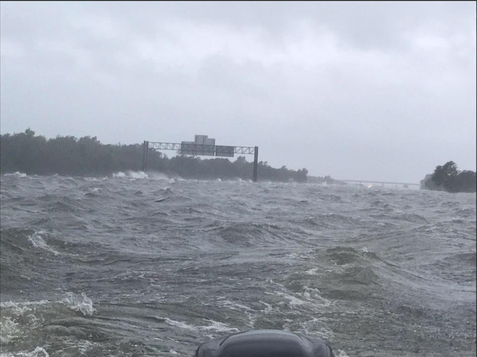
Heavy rain continues to ravage Southeast Texas as Harvey lingers over Texas. Then Harvey exits Texas and goes over the Gulf of Mexico. Heavy rain falls over East Texas. Beaumont gets over 31 inches of rain including over 26 inches in a single calendar day on August 29, 2017!

I-10 at Jefferson/Chambers County Line via Dade Phelan
https://www.weather.gov/hgx/hurricaneharvey

Many areas saw over 30 inches of rain from Harvey. The highest recorded is 60.58 inches of rain in Nederland. Some areas likely got over 60 inches of rain. A Personal Weather Station (PWS) in Baytown recorded over 66 inches of rain during Harvey from August 25-31, 2017. The August 2017 total for that station is over 74 inches! I would not be surprised if some areas got up to 80 inches of rain from Harvey.

Once Harvey passed, it did $125 billion in damage, which is comparable to Hurricane Katrina in 2005. 103 people lost their life from Harvey in Texas. It is the deadliest Texas hurricane since 1919. The 1919 Florida Keys hurricane claimed at least 284 lives in Texas. It is likely up to 1,000 people died. It is probable more people died during Harvey, but were not counted.

Ida Is Now A Hurricane

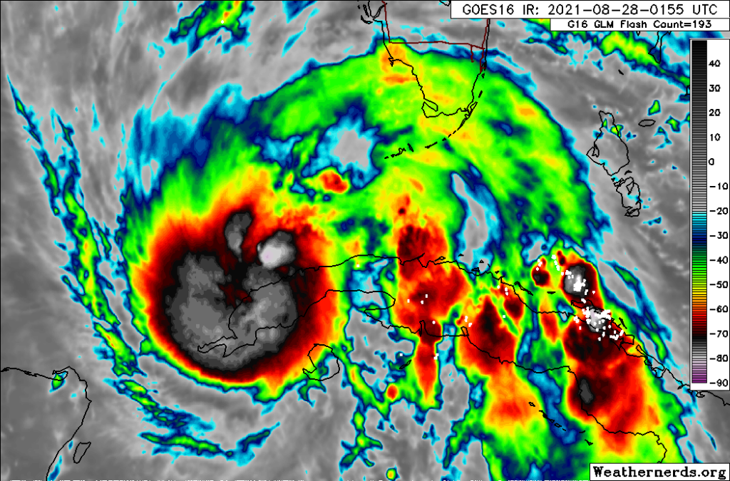
GOES-16 satellite image from Weathernerds.

The world cannot catch a break in this crazy year of 2021. 2021 is just as crazy as 2020. The terrorist attack in Kabul has claimed a total of 182 lives including 13 American service members. There are now over 216 million confirmed COVID-19 cases worldwide. America has reported over 190,000 new cases and 1,304 new deaths. This is as of August 27, 2021. As of tonight, Hurricane Ida is exiting Cuba and entering into the Gulf of Mexico.

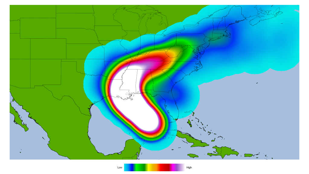
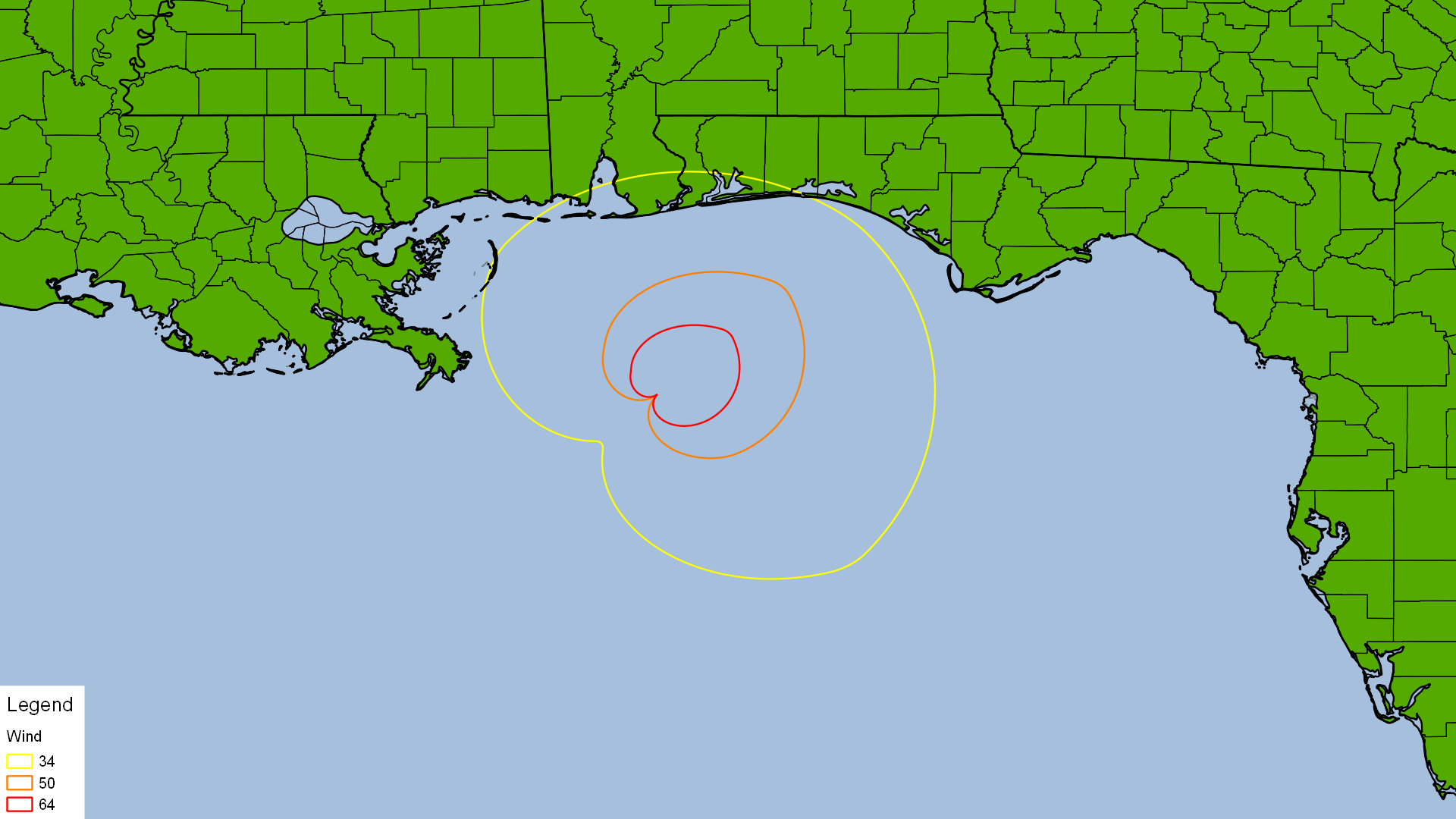
Here is a heat map from forecast models from the National Center for Atmospheric Research (NCAR). The heat is generated by QGIS. The heat map use points within 300 mile/480 kilometers radius. I used the latest forecast, which is 0000Z.

It is looking more likely Ida is going to make landfall somewhere between Louisiana, Mississippi, and Alabama. Texas and Florida are less likely to have Ida making landfall. The landfall risk includes New Orleans. New Orleans is mostly below sea level.

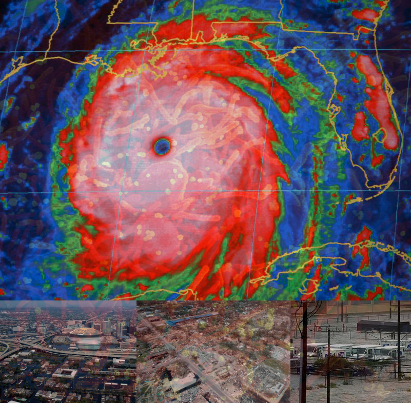
New Orleans was flooded out after Hurricane Katrina ravaged the Gulf Coast in 2005. New Orleans has pump stations to pump water out of the city. To make matters worse, some pump stations are out of service. Here is map of New Orleans pump stations that are online and offline. It is courtesy of The Times-Picayune and The New Orleans Advocate.

That would be a bad time if Ida is over them and the pumps are not fully online. If the dirty side of Ida is over New Orleans, there could be massive storm surge that floods the city. One area of concern is Lakeview, which is below sea level. Lakeview flooded after the levees failed from Hurricane Katrina. New Orleans area had 60 to 90 mph (96 to 144 km/h) winds with gusts of 90 to 135 mph (144 to 216 km/h) winds during Katrina. New Orleans area could have 100 to 120 mph (160 to 192 k/h) winds with gusts of 150 to 180 mph (240 to 270 km/h) from Ida.

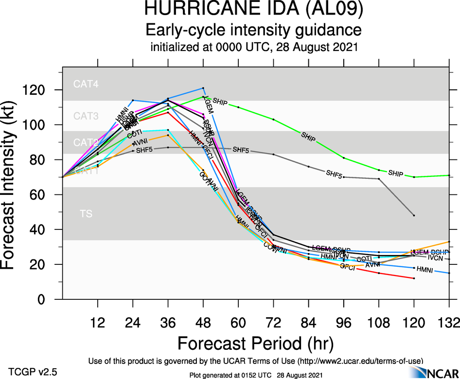
Looking at satellite image, the circular shape of Ida suggests it is starting to intensify. Here is an intensity forecast model for Ida.

Most forecast models have Ida as a Category 3 within 24 hours. A couple have Ida peaking at Category 4 hurricane. Intensity forecast models are not reliable. I would not be surprised if Ida undergoes rapid intensification. Come morning, Ida is likely to be a Category 4 hurricane. I would not be surprised if Ida ends up being a Category 5 hurricane. Here is something that is unsettling. New Orleans is not going to issue mandatory evacuations and contraflows. As mentioned, New Orleans is vulnerable from flooding. Storm surge will certainly flood the city. Here is an excerpt from the article:

Hurricane Ida is approaching New Orleans more rapidly than city officials had initially prepared for, Mayor LaToya Cantrell said in an evening press conference Friday.

The storm, now projected to hit the Gulf Coast as a major Category 4 hurricane on Sunday, is moving so fast that the city will not be able to issue a mandatory evacuation for residents or implement contraflow for those evacuating voluntarily. New Orleans is expected to feel the effects of Ida as early as Saturday night.

“It is vitally important. We want our people to be in their safe spaces by, and no later than midnight tomorrow,” said Cantrell.

That is very unsettling to think about. If Ida was to flood New Orleans, the city is going to be cut off from the world. There maybe no power and water and this is on top of COVID-19 pandemic. Many New Orleans area hospitals have COVID patients and some are on life support. Evacuating them will be a logistical nightmare. Here is a dire warning for Hurricane Katrina on August 28, 2005. It could apply with Ida:

URGENT - WEATHER MESSAGE
NATIONAL WEATHER SERVICE NEW ORLEANS LA
1011 AM CDT SUN AUG 28 2005

...DEVASTATING DAMAGE EXPECTED...

.HURRICANE KATRINA...A MOST POWERFUL HURRICANE WITH UNPRECEDENTED
STRENGTH...RIVALING THE INTENSITY OF HURRICANE CAMILLE OF 1969. 

MOST OF THE AREA WILL BE UNINHABITABLE FOR WEEKS...PERHAPS LONGER. AT
LEAST ONE HALF OF WELL CONSTRUCTED HOMES WILL HAVE ROOF AND WALL
FAILURE. ALL GABLED ROOFS WILL FAIL...LEAVING THOSE HOMES SEVERELY
DAMAGED OR DESTROYED.

THE MAJORITY OF INDUSTRIAL BUILDINGS WILL BECOME NON FUNCTIONAL.
PARTIAL TO COMPLETE WALL AND ROOF FAILURE IS EXPECTED. ALL WOOD
FRAMED LOW RISING APARTMENT BUILDINGS WILL BE DESTROYED. CONCRETE
BLOCK LOW RISE APARTMENTS WILL SUSTAIN MAJOR DAMAGE...INCLUDING SOME
WALL AND ROOF FAILURE.

HIGH RISE OFFICE AND APARTMENT BUILDINGS WILL SWAY DANGEROUSLY...A
FEW TO THE POINT OF TOTAL COLLAPSE. ALL WINDOWS WILL BLOW OUT.

AIRBORNE DEBRIS WILL BE WIDESPREAD...AND MAY INCLUDE HEAVY ITEMS SUCH
AS HOUSEHOLD APPLIANCES AND EVEN LIGHT VEHICLES. SPORT UTILITY
VEHICLES AND LIGHT TRUCKS WILL BE MOVED. THE BLOWN DEBRIS WILL CREATE
ADDITIONAL DESTRUCTION. PERSONS...PETS...AND LIVESTOCK EXPOSED TO THE
WINDS WILL FACE CERTAIN DEATH IF STRUCK.

POWER OUTAGES WILL LAST FOR WEEKS...AS MOST POWER POLES WILL BE DOWN
AND TRANSFORMERS DESTROYED. WATER SHORTAGES WILL MAKE HUMAN SUFFERING
INCREDIBLE BY MODERN STANDARDS.

THE VAST MAJORITY OF NATIVE TREES WILL BE SNAPPED OR UPROOTED. ONLY
THE HEARTIEST WILL REMAIN STANDING...BUT BE TOTALLY DEFOLIATED. FEW
CROPS WILL REMAIN. LIVESTOCK LEFT EXPOSED TO THE WINDS WILL BE
KILLED.

AN INLAND HURRICANE WIND WARNING IS ISSUED WHEN SUSTAINED WINDS NEAR
HURRICANE FORCE...OR FREQUENT GUSTS AT OR ABOVE HURRICANE FORCE...ARE
CERTAIN WITHIN THE NEXT 12 TO 24 HOURS.

ONCE TROPICAL STORM AND HURRICANE FORCE WINDS ONSET...DO NOT VENTURE
OUTSIDE!

$$

Reading that advisory from Katrina sends a chill down my spine. If Ida was to get close to New Orleans, it could be like Katrina again. Hopefully, that will not be the case.

I think Ida will be a major hurricane come morning. I would not be surprised if Ida is a Category 5 hurricane. Everyone along the Gulf Coast needs to be prepared right now. If you need to evacuate, please do so right now. It could be really bad.

Hurricane Sally, Wildfires, And COVID-19

The Atlantic is heating up with Paulette, Rene, Sally, Teddy, and Vicky. Rene is no more, while Paulette and Sally are hurricanes. Sally is the biggest threat as it is in the Gulf of Mexico, which I will discuss later. There are monster wildfires burning in California, Oregon, and Washington. This is all on top of the COVID-19 pandemic. As of 9/14/2020, there are over 29 million confirmed cases of COVID-19 with more than 932,000 deaths. There are over 7 million who are currently infected with more than 60,000 who are severely ill. It is from Worldometer. If you want to read my analysis on COVID-19, check out my other blog, The Ebola Zone. 2020 has been nothing but a terrible year all around no matter how one spins it. The whole world is of never ending disasters ranging from public health to weather. So much ground the cover.

The whole West is on fire. The whole West is covered in thick and acrid smoke. It is from Regional and Mesoscale Meteorology Branch (RAMMB)

Here is a heat map of active wildfires in the past 7 days. It is from Visible Infrared Imaging Radiometer Suite (VIIRS), which has a resolution of 375 meters or 1,230 feet. It is from NASA Active Fire Data. The heatmap is within 100 mile/160 kilometers radius from the point show.

It is really dire in the Western US. The whole West is on fire. Dire is a severe understatement. The death toll is probably going to be high once it is all over. Here is a Dense Smoke Advisory from NWS Reno.

URGENT - WEATHER MESSAGE
National Weather Service Reno NV
218 PM PDT Mon Sep 14 2020

CAZ070>073-NVZ001>005-160000-
/O.NEW.KREV.SM.Y.0009.200914T2118Z-200916T0000Z/
Surprise Valley California-Lassen-Eastern Plumas-
Eastern Sierra Counties-Greater Lake Tahoe Area-Mono County-
Mineral and Southern Lyon Counties-Greater Reno-Carson City-
Minden Area-Western Nevada Basin and Range including Pyramid Lake-
Northern Washoe County-
Including the cities of Cedarville, Eagleville, Fort Bidwell,
Portola, Susanville, Westwood, Sierraville, Loyalton,
South Lake Tahoe, Tahoe City, Truckee, Markleeville, Bridgeport,
Coleville, Lee Vining, Mammoth Lakes, Hawthorne, Yerington,
Smith Valley, Mina, Schurz, Stateline, Glenbrook,
Incline Village, Sparks, Verdi, Gardnerville, Virginia City,
Fernley, Fallon, Lovelock, Silver Springs, Nixon, Imlay, Empire,
and Gerlach
218 PM PDT Mon Sep 14 2020

...DENSE SMOKE ADVISORY IN EFFECT UNTIL 5 PM PDT TUESDAY...

* WHAT...Light west-southwest winds will continue to push smoke
into the region from several wildfires burning across
California. The near-surface smoke concentration may improve
during the afternoon today and tomorrow but looks to degrade
during the evening and overnight hours through Tuesday.

* WHERE...Western Nevada Basin and Range including Pyramid Lake,
Mineral and Southern Lyon Counties, Mono County, Surprise
Valley California, Lassen-Eastern Plumas-Eastern Sierra
Counties, Greater Lake Tahoe Area, Greater Reno-Carson City-
Minden Area and Northern Washoe County.

* WHEN...Until 5 PM PDT Tuesday.

* IMPACTS...Poor air quality and reduced visibility below one mile
in areas. Check airnow.gov for updated air quality information.

* ADDITIONAL DETAILS...The areas which will see the highest risk
of dense smoke will be the Eastern Sierra, Carson Valley, Smith
Valley, Hawthorne, and northeastern California.

PRECAUTIONARY/PREPAREDNESS ACTIONS...

Stay indoors as much as possible when smoke is present. Avoid
strenuous activity, especially if you are sensitive to poor air
quality, such as the elderly, children and anyone with chronic
illness or respiratory problems. Consider postponing outdoor
activities. Check airnow.gov for the latest air quality
information.

&&

$$

For more information from the National Weather Service visit
http://weather.gov/rev

People are advised to stay indoor. That is nearly impossible for people who have to evacuate in the fire zone. I do not know when the fires will end. The sooner the better. Anyways, let’s go to Hurricane Sally.

Hurricane Sally is a Category 2 hurricane with 100 mph winds. This as of 10:00 PM CDT from the National Hurricane Center (NHC). It is close to the coast and moving slowly.

000
WTNT34 KNHC 150311 CCA
TCPAT4

BULLETIN
Hurricane Sally Advisory Number 15...Corrected
NWS National Hurricane Center Miami FL AL192020
1000 PM CDT Mon Sep 14 2020

Corrected Storm Surge Hazards section

...OUTER RAIN BANDS MOVING ONSHORE IN THE FLORIDA PANHANDLE...
...LIFE-THREATENING STORM SURGE, HURRICANE-FORCE WINDS, AND FLASH
FLOODING LIKELY ALONG PORTIONS OF THE NORTHERN GULF COAST STARTING
LATER TONIGHT AND TUESDAY...

SUMMARY OF 1000 PM CDT...0300 UTC...INFORMATION
-----------------------------------------------
LOCATION...28.9N 87.6W
ABOUT 90 MI...145 KM E OF THE MOUTH OF THE MISSISSIPPI RIVER
ABOUT 130 MI...210 KM SE OF BILOXI MISSISSIPPI
MAXIMUM SUSTAINED WINDS...100 MPH...155 KM/H
PRESENT MOVEMENT...WNW OR 300 DEGREES AT 3 MPH...6 KM/H
MINIMUM CENTRAL PRESSURE...986 MB...29.12 INCHES

WATCHES AND WARNINGS
--------------------
CHANGES WITH THIS ADVISORY:

The Hurricane Warning west of Grand Isle to Morgan City, Louisiana,
has been downgraded to a Tropical Storm Warning.

SUMMARY OF WATCHES AND WARNINGS IN EFFECT:

A Storm Surge Warning is in effect for...
* Port Fourchon Louisiana to the Okaloosa/Walton County Line Florida
* Lake Pontchartrain, Lake Maurepas, and Lake Borgne
* Mobile Bay

A Hurricane Warning is in effect for...
* Grand Isle Louisiana to the Navarre Florida
* Lake Pontchartrain and Lake Maurepas including metropolitan New
Orleans

A Tropical Storm Warning is in effect for...
* East of of Navarre Florida to Indian Pass Florida
* West of Grand Isle to Morgan City Louisiana

A Storm Surge Warning means there is a danger of life-threatening
inundation, from rising water moving inland from the coastline,
during the next 36 hours in the indicated locations. For a depiction
of areas at risk, please see the National Weather Service Storm
Surge Watch/Warning Graphic, available at hurricanes.gov. This is a
life-threatening situation. Persons located within these areas
should take all necessary actions to protect life and property from
rising water and the potential for other dangerous conditions.
Promptly follow evacuation and other instructions from local
officials.

A Hurricane Warning means that hurricane conditions are expected
somewhere within the warning area. Preparations to protect life
and property should be rushed to completion.

A Tropical Storm Warning means that tropical storm conditions are
expected somewhere within the warning area within 36 hours.

For storm information specific to your area, including possible
inland watches and warnings, please monitor products issued by your
local National Weather Service forecast office.

DISCUSSION AND OUTLOOK
----------------------
At 1000 PM CDT (0300 UTC), the center of Hurricane Sally was located
near latitude 28.9 North, longitude 87.6 West. Sally is moving
toward the west-northwest near 3 mph (6 km/h) and this motion is
expected to continue through Tuesday morning. A northward turn is
likely by Tuesday afternoon, and a slow north-northeastward to
northeastward motion is expected Tuesday night through Wednesday
night. On the forecast track, the center of Sally will move near
the coast of southeastern Louisiana tonight and Tuesday, and make
landfall in the hurricane warning area Tuesday night or Wednesday.

Maximum sustained winds are near 100 mph (155 km/h) with higher
gusts. Some strengthening is forecast early Tuesday and Sally is
expected to be a dangerous hurricane when it moves onshore along the
north-central Gulf coast.

Hurricane-force winds extend outward up to 45 miles (75 km) from the
center and tropical-storm-force winds extend outward up to 125 miles
(205 km). A buoy south of Dauphin Island, Alabama, recently
reported sustained winds of 61 mph (98 km/h) and a wind gust of 69
mph (111 km/h).

The estimated minimum central pressure based on data from the
NOAA and Air Force Hurricane Hunters is 986 mb (29.12 inches).

HAZARDS AFFECTING LAND
----------------------
Key messages for Sally can be found in the Tropical Cyclone
Discussion under AWIPS header MIATCDAT4 and WMO header WTNT44 KNHC,
and on the web at www.hurricanes.gov/text/MIATCDAT4.shtml

STORM SURGE: The combination of a dangerous storm surge and the
tide will cause normally dry areas near the coast to be flooded by
rising waters moving inland from the shoreline. The water could
reach the following heights above ground somewhere in the indicated
areas if the peak surge occurs at the time of high tide...

Mouth of the Mississippi River to Dauphin Island including Lake
Borgne...6-9 ft
Mobile Bay...6-9 ft
Lake Pontchartrain and Lake Maurepas...3-5 ft
Dauphin Island to AL/FL Border...4-7 ft
Port Fourchon to Mouth of the Mississippi River...2-4 ft
AL/FL Border to Okaloosa/Walton County Line including Pensacola Bay
an Choctawhatchee Bay...2-4 ft
Okaloosa/Walton County Line to Chassahowitzka including Saint Andrew
Bay...1-3 ft
Burns Point to Port Fourchon...1-2 ft

Overtopping of local levees outside of the Hurricane and Storm
Damage Risk Reduction System is possible where local inundation
values may be higher than those shown above.

The deepest water will occur along the immediate coast in areas of
onshore winds, where the surge will be accompanied by large and
damaging waves. Surge-related flooding depends on the relative
timing of the surge and the tidal cycle, and can vary greatly over
short distances. For information specific to your area, please see
products issued by your local National Weather Service forecast
office.

WIND: Hurricane conditions are expected to begin within the
hurricane warning area later tonight and Tuesday. Tropical storm
conditions expected to begin within the warning area during the
next few hours.

RAINFALL: Sally is expected to be a slow moving system as it
approaches land, producing 8 to 16 inches of rainfall with isolated
amounts of 24 inches over portions of the central Gulf Coast from
the western Florida Panhandle to far southeastern Mississippi
through the middle of the week. Life-threatening flash flooding is
likely. In addition, this rainfall will likely lead to widespread
minor to isolated major flooding on area rivers.

Sally is forecast to turn inland early Wednesday and track across
the Southeast producing rainfall of 4 to 8 inches, with isolated
maximum amounts of 12 inches, across portions of eastern
Mississippi, central Alabama, northern Georgia, southeastern
Tennessee, and the western Carolinas. Significant flash and urban
flooding is likely, as well as widespread minor to moderate flooding
on some rivers.

Outer bands of Sally could produce additional rainfall of 1 to 3
inches across the Florida peninsula through tonight. This rainfall
may produce flash and urban flooding and prolong high flows and
ongoing minor flooding on rivers across central Florida.

TORNADOES: A tornado or two will be possible late tonight through
early Tuesday in coastal areas of the Florida Panhandle and Alabama.
The threat for tornadoes should increase and slowly spread inland
during the day on Tuesday.

SURF: Swells from Sally will continue to affect the coast from the
Florida Big Bend westward to southeastern Louisiana during the next
couple of days. These swells are likely to cause life-threatening
surf and rip current conditions. Please consult products from your
local weather office.

NEXT ADVISORY
-------------
Next intermediate advisory at 100 AM CDT.
Next complete advisory at 400 AM CDT.

$$
Forecaster Cangialosi/Stewart

How strong will Sally get? Here is an intensity forecast. The data and intensity forecast are from NCAR-Tropical Cyclone Guidance.

Most forecast model keep Sally at Category 2. The exception is SHF5, which has it as a Category 3 hurricane. I think Sally will become a Category 3 hurricane and make landfall as one somewhere along the Central Gulf Coast. Many are wondering where Sally will go. Here is a heat map using points within 300 mile/480 kilometers radius. I used the latest forecast, which is 0000Z. All GIS maps are created from QGIS.

Most models have Sally making landfall on Mississippi or Alabama on Tuesday night to early Wednesday morning. The slow motion of the hurricane increases chance of higher storm surge and heavier rain. Flooding would be a serious problem for areas affected by Sally. As I am typing, tropical storm force winds are affecting Alabama, Florida, and Louisiana. It should reach Mississippi later tonight.

Hurricane force winds extend up to 45 miles from the center with tropical storm force winds extending up to 125 miles. Sally is not a large hurricane. Smaller hurricanes produce lower storm surge. However, the slow movement is likely to produce higher storm surge. It is also the width and and slope of the ocean bottom that is a factor as well. The area where Sally is has produced monster storm surge from Camille and Katrina. I am not expecting storm surge comparable to Camille or Katrina at this time.

So much weather events going on in America on top of COVID-19 pandemic that is ravaging the world. Hopefully, anyone who needed to evacuate did evacuate.

Katrina, Fifteen Years Later

We are in a time of uncertainty from the COVID-19 pandemic as the coronavirus spreads around the world. Hurricane Laura ravaged Southwest Louisiana as a Category 4 monster. Coronavirus and hurricanes add to so much uncertainty in these times in 2020. Let’s look back at Hurricane Katrina. It is hard to believe it has been fifteen years ago that Hurricane Katrina ravaged the Gulf Coast on August 29, 2005. Katrina ties with Harvey as the most costliest hurricane to this very day. The monsterous storm surge flooded Mississippi, Louisiana, and Alabama. Monster storm surge that ravaged Mississippi eclipsed Hurricane Camille in 1969. The same storm surge that caused flood walls and levees to fail in New Orleans and St. Bernard Parish. The flooding caused New Orleans area to be uninhabitable for months.

So, how it all begin? Mesoscale Convective System (MCS) form over Central Africa. Than on August 8, 2005, the cluster of thunderstorms emerge over the Atlantic. It travels across the Atlantic Ocean. Than on August 11, 2005, the thunderstorms become better organized. It becomes Tropical Depression 10. Meanwhile, another tropical wave with the same origin as Tropical Depression 10 has emerged. It too started as a MCS over Central Africa. Both tropical waves are spawned by monsoons over Africa.

20050808_Meteosat-8_IR_Color_1500Z

Tropical Depression 10 had to deal with strong wind shear from a tropospheric trough. The wind shear eventually killed Tropical Depression 10 by August 14. Had Tropical Depression 10 be named, it would have been Jose. The tropical wave that emerged on August 11 continues traveling towards the Bahamas.

20050813_MODIS_10L_1550Z

Despite the wind shear, thunderstorms continue to persist in what was Tropical Depression 10. The remnant of Tropical Depression 10 dissipates on August 18. What remains of Tropical Depression 10 runs into a tropical wave that left Africa on August 11. The two systems with its origin in Africa begin to merge north of Puerto Rico on August 19. Tropical Depression 10 is being revived albeit without the lower level circulation. The two storms have merged and moving towards Bahamas. Than on August 23rd, the thunderstorms become better organized and becomes Tropical Depression 12.

20050824_VIS_Katrina_1315Z

Tropical Depression 12 becomes better organized and becomes Katrina. Katrina is rapidly intensifying. Had it had more time over the warm Atlantic, Katrina could have been a Category 3 hurricane. Katrina makes it first landfall on South Florida as a small Category 1 hurricane with 80 mph winds on August 25th at 7:25 PM. It had hurricane force winds extend up to 10 miles. It caught people off guard as Katrina traverses over South Florida with strong winds and heavy rain.

20050825_KMFL_DopplerRadar_2300Z

In South Florida, there is flooding and wind damage from Katrina. The highest wind on land from Katrina is 68 mph with gusts as high as 102 mph. Many areas see 10 to 15 inches of rain from Katrina. Katrina exits South Florida into the warm Gulf of Mexico was a tropical storm. The weakness is short lived as it becomes a hurricane again. 14 people lost their life from Katrina as it did $623 million in damages.

Hurricane Katrina is over the warm Gulf of Mexico intensifying and getting larger. The once midget hurricane is getting larger thanks to large area of humid airs and warm Gulf of Mexico. Than Katrina becomes a major hurricane with 115 mph on August 27. Katrina undergoes explosive intensification on the night of August 27 to 28. Waves are building up on the Gulf Coast as Katrina is making its presence felt.

20050828_GOES_IR_GOM_0045Z

By the morning of August 28, Katrina is a monsterous Category 5 hurricane with 175 mph winds. It has a central pressure of 902 millibars, making it the fourth strongest Atlantic hurricane at the time. It is a very large hurricane and has its sights on the Gulf Coast. Forecast models have it going near New Orleans.

20050828_GOES_IR_Color_GOM_1845Z

New Orleans is below sea level and vulnerable to high storm surge. People have to evacuate the city to avoid the dangerous storm surge. NWS WFO in Slidell issued this dire weather bulletin as Katrina underwent explosive intensification.

000
WWUS74 KLIX 281550
NPWLIX

URGENT — WEATHER MESSAGE
NATIONAL WEATHER SERVICE NEW ORLEANS LA
1011 AM CDT SUN AUG 28, 2005

…DEVASTATING DAMAGE EXPECTED…

HURRICANE KATRINA…A MOST POWERFUL HURRICANE WITH UNPRECEDENTED
STRENGTH… RIVALING THE INTENSITY OF HURRICANE CAMILLE OF 1969.

MOST OF THE AREA WILL BE UNINHABITABLE FOR WEEKS…PERHAPS LONGER. AT
LEAST ONE HALF OF WELL CONSTRUCTED HOMES WILL HAVE ROOF AND WALL
FAILURE. ALL GABLED ROOFS WILL FAIL…LEAVING THOSE HOMES SEVERELY
DAMAGED OR DESTROYED.

THE MAJORITY OF INDUSTRIAL BUILDINGS WILL BECOME NON FUNCTIONAL.
PARTIAL TO COMPLETE WALL AND ROOF FAILURE IS EXPECTED. ALL WOOD
FRAMED LOW RISING APARTMENT BUILDINGS WILL BE DESTROYED. CONCRETE
BLOCK LOW RISE APARTMENTS WILL SUSTAIN MAJOR DAMAGE…INCLUDING SOME
WALL AND ROOF FAILURE.

HIGH RISE OFFICE AND APARTMENT BUILDINGS WILL SWAY DANGEROUSLY…A
FEW TO THE POINT OF TOTAL COLLAPSE. ALL WINDOWS WILL BLOW OUT.

AIRBORNE DEBRIS WILL BE WIDESPREAD…AND MAY INCLUDE HEAVY ITEMS SUCH
AS HOUSEHOLD APPLIANCES AND EVEN LIGHT VEHICLES. SPORT UTILITY VEHICLES
AND LIGHT TRUCKS WILL BE MOVED. THE BLOWN DEBRIS WILL CREATE
ADDITIONAL DESTRUCTION. PERSONS…PETS…AND LIVESTOCK EXPOSED TO THE
WINDS WILL FACE CERTAIN DEATH IF STRUCK.

POWER OUTAGES WILL LAST FOR WEEKS…AS MOST POWER POLES WILL BE DOWN
AND TRANSFORMERS DESTROYED. WATER SHORTAGES WILL MAKE HUMAN SUFFERING
INCREDIBLE BY MODERN STANDARDS.

THE VAST MAJORITY OF NATIVE TREES WILL BE SNAPPED OR UPROOTED. ONLY
THE HEARTIEST WILL REMAIN STANDING…BUT BE TOTALLY DEFOLIATED. FEW
CROPS WILL REMAIN. LIVESTOCK LEFT EXPOSED TO THE WINDS WILL BE
KILLED.

AN INLAND HURRICANE WIND WARNING IS ISSUED WHEN SUSTAINED WINDS NEAR
HURRICANE FORCE…OR FREQUENT GUSTS AT OR ABOVE HURRICANE FORCE…ARE
CERTAIN WITHIN THE NEXT 12 TO 24 HOURS.

ONCE TROPICAL STORM AND HURRICANE FORCE WINDS ONSET…DO NOT VENTURE
OUTSIDE!

Mandatory evacuations have been ordered for people in coastal areas including New Orleans. Some people who cannot evacuate end up at a refuge of last resort, the Superdome. About 14,000 people have taken up shelter at the Superdome. Something that would prove disasterous later on.

New Orleans, LA. August 28, 2005 -- Residents are bringing their belongings and lining up to get into the Superdome which has been opened as a hurricane shelter in advance of hurricane Katrina. Most residents have evacuated the city and those left behind do not have transportation or have special needs. Marty Bahamonde/FEMA

Katrina is barreling towards the Gulf Coast as a Category 5 hurricane. It weakens due to eyewall replacement cycle and dry air from America as it is now a Category 4 hurricane with 150 mph winds. The outer bands of Katrina are affected Louisiana, Mississippi, and Alabama. The outer bands produce squally weather. Each feeder bands get more intense as Katrina gets closer. The Mississippi Delta is experiencing hurricane force winds with heavy rain and storm surge. Conditions are deteriorating throughout the Gulf Coast as Katrina is moving northwards.

20050829_GOES-12_IR_Enhanced_0045Z

Storm surge and waves are getting higher in Louisiana and Mississippi as the weather gets worse. People are hunkered down in hopes they survive. The winds get stronger and rain heavier as Katrina is getting closer and closer by the minute.

20050829_KLIX_DopplerRadar_1332Z

Than at 6:10 AM, Katrina makes it first landfall on Louisiana as a Category 3 hurricane with 125 mph winds. On land, due to friction, the highest land wind is 106 mph with gust as high as 160 mph. It has a central pressure of 920 millibars, making it the third strongest hurricane to make landfall on America. Only 1935 Labor Day Hurricane and Camille are stronger. Interestingly, Camille made landfall in the same area as Katrina is about to on August 18, 1969. It could be said that Katrina is the cousin of Camille.

KatrinaSustainedGulfCoast

KatrinaGustGulfCoast

Storm surge is getting higher and higher in Louisiana as Katrina moves northward. It goes east of New Orleans a couple hours after it made its first landfall. New Orleans is on the west side of Katrina, which is the so called “clean” side of the storm. Regardless, storm surge is getting higher around New Orleans including Lake Ponchartrain to the north. As Katrina is heading towards Mississippi, the flood walls and levees begin to fail, allowing water to flood New Orleans and surrounding areas.

KatrinaSlidell01

In St. Bernard Parish, flood waters are reaching up to roof level. The storm surge is from Mississippi River–Gulf Outlet Canal (MRGO) and Industrial Canal. It is the same storm surge that is heading towards Mississippi. The breached levees and flood walls flooding St. Bernard Parish is also flooding New Orleans.

KatrinaStBernard01

Katrina makes it second landfall on the Gulf Coast at 9:45 AM. Katrina is still a Category 3 hurricane with 120 mph winds. The highest wind is 102 mph with gusts as high as 153 mph. Katrina’s central pressure rises to 927 millibars, a still very intense hurricane by all measures. It is over Coastal Mississippi, as it takes the full brunt from Katrina. Massive storm surge hammers the coast. Storm surge rises rapidly in Mississippi as anyone at the coast has very little time to escape. Storm surge as high as 35 feet flood the coast. Anyone who did not evacuate are in deep trouble. They could drown and be swept away by the deadly storm surge.

The strong winds and heavy rain are destroying buildings in Mississippi and Louisiana. Most of New Orleans is starting as water comes out of the drains as Katrina is going inland over Mississippi. Flood waters are rapidly rising in New Orleans and surrounding areas. By the evening of of August 29, Katrina is far inland over Mississippi as a Category 1 hurricane. Flood waters are continuing to rise in New Orleans and St Bernard Parish. This is on top of the heavy rain Katrina dumped on the Gulf Coast. Many areas see 8 to 12 inches of rain with amounts as high as 16 inches.

KatrinaRainfallTotalGulfCoast

Storm surge has subsided in Mississippi as it reveals the catastrophic damage unleashed by Katrina. It looks like if a powerful nuclear bomb exploded over Mississippi. Meanwhile in Louisiana, the scene is similar in Slidell and Buras, leveled buildings from storm surge. New Orleans and St Bernard Parish are underwater as they lie below sea level from breached levees and flood walls meant to protect the area from storm surge. They failed and allowed the area to be inundated with flood water.

KatrinaNewOrleansFlood01

KatrinaMississippi01

KatrinaBiloxi01

KatrinaBurasWatertower

New Orleans became a ghost town as most of the city is rendered uninhabitable from the contaminated flood waters. The Superdome and New Orleans Morial Convention Center become scenes of refugees who lost everything from Katrina. The situation at the Superdome is getting worse and worse as more people come and supplies are almost non-existent. A scene only seen in Third World nations, happening in America. It becomes crowded with people who have nowhere to go.

There are many stranded people on roofs who are being rescued by helicopter or boat. Since, order has been lost, looting and crime become a serious problem in New Orleans. People have to be evacuated from the city to other cities throughout the South and America. Many are evacuated to Houston and many are in the Astrodome. Some go to Baton Rouge, Dallas, and Atlanta.

KatrinaHelicopterRescue01

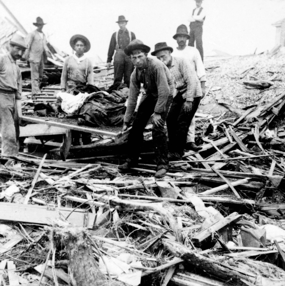
Katrina is the deadliest hurricane to strike America since the 1928 Okeechobee Hurricane. It claimed over 4,000 lives in Florida and Puerto Rico. The deadliest American hurricane is the Great Galveston Hurricane of 1900. The hurricane claimed 12,000 lives, mostly from storm surge. It remains America’s deadliest disaster to this very day.

GalvestonHurricane1900_BodyCarry01

Katrina is second disaster to kill over a thousand in America in the same decade of 2000s. The first disaster that claimed over a thousands lives in the 2000s is the 9/11 Terrorist Attacks that claimed 3,000 lives in 2001. Four hijacked airplanes crash into the World Trade Center and Pentagon. A fourth hijacking, United Airlines Flight 93 is thwarted. The attack left the World Trade Center a toxic mess and Pentagon burning. Many people who were exposed to toxic dust and smoke have developed various illnesses and have died. The last time that happened in history is the 1900s, the Great Galveston Hurricane of 1900 and 1906 San Francisco Earthquake. They are in fact the deadliest disasters to strike America.

The rubble of the World Trade Center smoulders following the Sept. 11, 2001 attack in New York City. 14 June 2007 (B8) no cutline

Top 10 Deadliest Disasters In America
1.) 1900 Galveston Hurricane September 8, 1900 12,000
2.) 1906 San Francisco Earthquake April 18, 1906 6,000
3.) 1899 San Ciriaco Hurricane August 8, 1899 3,389
4.) 9/11 Terrorist Attacks September 11, 2001 3,000
5.) Hurricane Maria September 20, 2017 2,982
6.) 1928 Okeechobee Hurricane September 13 and 16, 1928 +2,823
7.) Pearl Harbor Attack December 7, 1941 2,466
8.) Johnstown Flood May 31, 1889 2,209
9.) 1893 Cheniere Caminada Hurricane October 2, 1893 2,000
10.) Hurricane Katrina August 29, 2005 1,833

It is from Wikipedia. The list excludes droughts, epidemics, and wars.

Unsurvivable Storm Surge With Large And Destructive Waves

NOAA/NESDIS/STAR GOES ABI BAND 13 OR_ABI-L1b-RadC-M6C13_G16_s20202400211172_e20202400213557_c20202400214020.nc

Straight out of the National Hurricane Center (NHC) advisory. Very ominous wording from them. Anyone who has not escaped from the coast are going to be in a very long and rough night ahead. Hurricane Laura is going to be a very brutal hurricane for Southwest Louisiana and East Texas.

000
WTNT33 KNHC 262342
TCPAT3

BULLETIN
Hurricane Laura Intermediate Advisory Number 28A
NWS National Hurricane Center Miami FL AL132020
700 PM CDT Wed Aug 26 2020

...WINDS INCREASING AS EXTREMELY DANGEROUS HURRICANE LAURA TAKES AIM
AT THE NORTHWEST GULF COAST...
...CATASTROPHIC STORM SURGE, EXTREME WINDS, AND FLASH FLOODING
EXPECTED ALONG THE NORTHWEST GULF COAST TONIGHT...

SUMMARY OF 700 PM CDT...0000 UTC...INFORMATION
----------------------------------------------
LOCATION...28.4N 92.9W
ABOUT 120 MI...190 KM S OF LAKE CHARLES LOUISIANA
ABOUT 120 MI...190 KM SSE OF PORT ARTHUR TEXAS
MAXIMUM SUSTAINED WINDS...150 MPH...240 KM/H
PRESENT MOVEMENT...NNW OR 330 DEGREES AT 15 MPH...24 KM/H
MINIMUM CENTRAL PRESSURE...940 MB...27.76 INCHES

WATCHES AND WARNINGS
--------------------
CHANGES WITH THIS ADVISORY:

None.

SUMMARY OF WATCHES AND WARNINGS IN EFFECT:

A Storm Surge Warning is in effect for...
* Freeport Texas to the Mouth of the Mississippi River

A Hurricane Warning is in effect for...
* San Luis Pass Texas to Intracoastal City Louisiana

A Tropical Storm Warning is in effect for...
* Sargent Texas to San Luis Pass
* East of Intracoastal City Louisiana to the Mouth of the
Mississippi River

A Hurricane Watch is in effect for...
* East of Intracoastal City to west of Morgan City Louisiana

A Storm Surge Warning means there is a danger of life-threatening
inundation, from rising water moving inland from the coastline in
the indicated locations. For a depiction of areas at risk, please
see the National Weather Service Storm Surge Watch/Warning Graphic,
available at hurricanes.gov. This is a life-threatening situation.
Persons located within these areas should take all necessary
actions to protect life and property from rising water and the
potential for other dangerous conditions. Promptly follow
evacuation and other instructions from local officials.

A Hurricane Warning means that hurricane conditions are expected
somewhere within the warning area. Preparations to protect life
and property should be rushed to completion.

A Hurricane Watch means that hurricane conditions are possible
within the watch area.

A Tropical Storm Warning means that tropical storm conditions are
expected somewhere within the warning area.

For storm information specific to your area, including possible
inland watches and warnings, please monitor products issued by your
local National Weather Service forecast office.

DISCUSSION AND OUTLOOK
----------------------
At 700 PM CDT (0000 UTC), the eye of Hurricane Laura was located
near latitude 28.4 North, longitude 92.9 West. Laura is moving
toward the north-northwest near 15 mph (24 km/h). A turn toward the
north is expected overnight, and a northward motion should continue
on Thursday. A northeastward to east-northeastward motion is
expected Thursday night and Friday. On the forecast track, Laura
will approach the upper Texas and southwest Louisiana coasts this
evening and move inland within that area tonight. The center of
Laura is forecast to move over northwestern Louisiana tomorrow,
across Arkansas Thursday night, and over the mid-Mississippi Valley
on Friday.

Reports from a NOAA Hurricane Hunter aircraft indicate that the
maximum sustained winds have increased to near 150 mph (240 km/h)
with higher gusts. Laura is an extremely dangerous category 4
hurricane on the Saffir-Simpson Hurricane Wind Scale. Some
additional strengthening is possible tonight before Laura reaches
the northwest Gulf coast overnight. Rapid weakening is expected
after Laura moves inland.

Hurricane-force winds extend outward up to 60 miles (95 km) from
the center and tropical-storm-force winds extend outward up to 205
miles (335 km). A sustained wind of 48 mph (78 km/h) was recently
reported at Cypremort Point, Louisiana, on Vermilion Bay.

The minimum central pressure estimated from NOAA Hurricane Hunter
aircraft observations is 940 mb (27.76 inches).

HAZARDS AFFECTING LAND
----------------------
Key messages for Laura can be found in the Tropical Cyclone
Discussion under AWIPS header MIATCDAT3 and WMO header WTNT43 KNHC.

Storm surge and tropical-storm-force winds will arrive within the
warning areas well in advance of Laura's center. All preparations
to protect life and property should be rushed to completion in the
next few hours.

STORM SURGE: The combination of a dangerous storm surge and the
tide will cause normally dry areas near the coast to be flooded by
rising waters moving inland from the shoreline. The water could
reach the following heights above ground somewhere in the indicated
areas if the peak surge occurs at the time of high tide...

Johnson Bayou LA to Rockefeller Wildlife Refuge including Calcasieu
Lake...15-20 ft
Sea Rim State Park TX to Johnson Bayou LA including Sabine
Lake...10-15 ft
Rockefeller Wildlife Refuge to Intracoastal City LA...10-15 ft
Intracoastal City LA to Morgan City including Vermilion Bay...8-12
ft
Port Bolivar TX to Sea Rim State Park...6-9 ft
Morgan City LA to Mouth of the Mississippi River...4-7 ft
Freeport TX to Port Bolivar including Galveston Bay...2-4 ft
Mouth of the Mississippi River to Ocean Springs MS including Lake
Borgne...1-3 ft
Lake Pontchartrain and Lake Maurepas...1-3 ft

The deepest water will occur along the immediate coast near and to
the right of the landfall location, where the surge will be
accompanied by large and destructive waves.

Unsurvivable storm surge with large and destructive waves will cause
catastrophic damage from Sea Rim State Park, Texas, to Intracoastal
City, Louisiana, including Calcasieu and Sabine Lakes. This surge
could penetrate up to 40 miles inland from the immediate coastline,
and flood waters will not fully recede for several days after the
storm.

Surge-related flooding depends on the relative timing of the surge
and the tidal cycle, and can vary greatly over short distances. For
information specific to your area, please see products issued by
your local National Weather Service forecast office.

WIND: Hurricane conditions are expected in the hurricane warning
area tonight and Thursday, with catastrophic wind damage expected
where Laura's eyewall moves onshore tonight. Tropical storm
conditions are moving onshore along the coast of Louisiana within
the tropical storm warning area and are expected to spread
northwestward within the warning areas this evening.

Hurricane-force winds and damaging wind gusts are also expected to
spread well inland into portions of eastern Texas and western
Louisiana early Thursday.

RAINFALL: From this evening through Friday, Laura is expected to
produce the following rainfall totals:

Across the northwestern Gulf Coast from far southwest Louisiana and
the Golden Triangle of Southeast Texas: 8 to 12 inches with isolated
totals of 18 inches.

Across central and the rest of western Louisiana into far eastern
Texas: 5 to 10 inches with isolated totals of 15 inches.

Across much of Arkansas: 3 to 7 inches with isolated totals of 10
inches.

This rainfall will cause widespread flash and urban flooding, small
streams and creeks to overflow their banks, and minor to moderate
freshwater river flooding.

By Friday into Saturday, Laura is expected to produce the following
rainfall totals:

Across the mid-Mississippi and portions of the Tennessee Valley,
Lower Ohio Valley, and central Appalachians: 2 to 4 inches with
isolated maximum amounts of 6 inches.

This rainfall may lead to flash and urban flooding and rapid rises
on small streams.

Across the Mid-Atlantic Region: 1 to 3 inches.

TORNADOES: Several tornadoes are expected this evening through
tonight over Louisiana, far southeast Texas, and southwestern
Mississippi. The risk for a few tornadoes will continue into
Thursday across Louisiana, Arkansas, and western Mississippi.

SURF: Swells produced by Laura are affecting the U.S. Gulf coast
from the west coast of Florida to Texas and northeastern Mexico.
These swells are likely to cause life-threatening surf and rip
current conditions. Please consult products from your local
weather office.

NEXT ADVISORY
-------------
Next complete advisory at 1000 PM CDT.

$$
Forecaster Pasch

Hurricane Laura is a dangerous Category 4 hurricane with 150 mph winds as of 10:00 PM CDT. It is a fairly large hurricane with hurricane force winds extending up to 60 miles from the eye. Tropical storm force winds extend up to 205 miles from the eye. Folks, a large hurricane is going to produce monster storm surge. To make matters worse, there is the COVID-19 pandemic. A monster hurricane barreling towards the coast is bad enough, but with COVID-19, it makes it astronomically worse. The coronavirus could spread among evacuees. 2020 is nothing but uncertainties and anxiety. Here is a wind swath map of Laura. It is a GIS file from the NHC. All GIS maps are created from QGIS.

It is a very large hurricane. Hurricane force winds from the northeast to southeast quadrant is 120 miles across! If it goes over land, it will be reduced by 15 percent due to land interaction. It reduces it to 102 miles and is moving at 15 mph. People on the eastern half of Laura could experience hurricane force winds for 7 hours! Hurricane force wind is a scary to hear, especially at night. I have been through hurricane force winds. It is something you never forget. Many are wondering where Hurricane Laura will go. Here is a heat map using points within 300 mile/480 kilometers radius. I used the latest forecast, which is 0000Z, including the GFS ensemble from 1800Z, and 0000Z forecast to create the heat map. The data and intensity forecast are from NCAR-Tropical Cyclone Guidance

Most of the forecast models have it heading to East Texas or Louisiana. I am not going to say where Hurricane Laura will make landfall. It does not matter where it makes landfall as it will produce monster and deadly storm surge far inland. As for how strong Laura will be. Here is an intensity forecast model.

Most forecast models have Hurricane Laura as a Category 4. One has it as a Category 5. I would not be surprised one bit if Hurricane Laura becomes a Category 5 right before landfall. It will be very devastating regardless of Category 4 or 5. Here is a Doppler radar image out of NWS Lake Charles.

Very ominous looking hurricane. It is going to be a very long and frightening night for Louisiana, especially for anyone who has not evacuated.

Invest 91L As Barry?

Invest 91L is in the Gulf of Mexico. It is a low pressure area with thunderstorms. The National Hurricane Center gives it a moderate chance of developing in the next few days. The biggest question is where does Invest 91L go. Here is a heat map generated from forecast models from NCAR-Tropical Cyclone Guidance. It is within 300 miles of a forecast track point.

The forecast models have Invest 91L heading northward towards Texas. It could hug the Texas Coast or make landfall somewhere on Texas. Not often a tropical system hugs the Texas Coast like this. The 1837 Racer’s Hurricane hugged the Texas Coast before making landfall in the Southern US. It was a hurricane, unlike Invest 91L. That leads to the next question, how strong will 91L be?

The intensity forecast is from NCAR-Tropical Cyclone Guidance. The intensity forecast models keep Invest 91L below tropical storm. I do not put a lot of weight on intensity forecast models. They are unreliable. I would not be surprised if 91L becomes a tropical storm, which would be Barry.

Here is what I think will happen.
-Invest 91L could become Barry.
-Regardless of development, heavy rain will be the main problem for Texas, Louisiana, and Arkansas.
-Flooding is likely where heavy rain falls.

Invest 91L bears watching between now to the end of the week.

Hurricane Ike 10 Years Later

Before Harvey flooded out Southeast Texas, there was Ike. It is hard to believe it has been 10 years since Hurricane Ike made landfall on Southeast Texas as a monsterous Category 2 hurricane in the early morning hours of September 13, 2008. Especially the fact this comes in light of Harvey. Ike pelted Southeast Texas and Southwest Louisiana with hurricane force winds and heavy rain. Ike was the last hurricane to hit Texas prior to Harvey. Almost a nine year gap of no hurricanes hitting Texas, let alone a major hurricane. The last major hurricane to hit Texas prior to Harvey was Bret in 1999, which is 18 years.

Thunderstorms over Sudan that later became Ike.

What is the origin of Hurricane Ike? Ike started as a mesoscale convective system (MCS) that formed over Sudan on August 19th. Most tropical waves come from thunderstorms that form in the Northeast part of Africa. They are set off by the Intertropical Convergence Zone (ITCZ) or monsoon. The ITCZ is where there is thunderstorms from the clash of trade winds. These thunderstorms often provide beneficial rains in tropical and subtropical areas. The thunderstorms in ITCZ can break away and travel away. One of those thunderstorms from the ITCZ managed to do that. The MCS traveled over Africa and entered the Atlantic Ocean as a tropical wave on August 29th. The tropical wave traveled across with multiple vortices competing. One of them would win out as the thunderstorms in the tropical wave get better organized on September 1, 2008. It is upgraded to Tropical Depression #9. Later that day, it is named Ike as it travels over the open Atlantic. Tropical Storm Ike has to deal with wind shear in the upper level early in its life. The wind shear blows tops of thunderstorms, especially westerly wind shear. Since 2008 season is Neutral to La Nina, conditions are more favorable as there is less westerly wind shear. If 2008 was El Nino, there would be more westerly wind shear, which is why generally El Nino Atlantic Hurricane seasons see less storms. Wind shear generally kills tropical development. The higher the storm clouds are, the cooler it is. Higher storm clouds also mean they are more intense.

However, Ike gets a reprieve as the wind shear weakens and encounter warmer waters on September 3rd. This allows Ike to rapidly intensify into a major hurricane. By the next day, Ike becomes 2008’s strongest hurricane with 145 mph 126 knots 233 km/h winds and central pressure of 935 millibars. Ike’s strength did not last as it encountered wind shear on September 5th. The wind shear weaken Ike to Category 2 strength.

Hurricane Ike around its peak.

Ike is pushed southwards into more favorable areas due to upper level ridge to the north. Ike becomes a Category 4 hurricane as conditions are more favorable. As it goes westward, Ike made its first landfall on Turks and Caicos Islands as a Category 4 hurricane on the early morning hours of September 7th. The Turks and Caicos Islands are the first to feel Ike’s violent wrath in the form of strong winds, heavy rain, storm surge, and high waves. The South Caicos and Grand Turk take the brunt of Ike. Despite Ike’s fury, there are no reports of fatalities.

Damage in Grand Turk.

While Ike is ravaging the Turks and Caicos Islands, the outer bands of Ike are dumping heavy rain on Haiti and Dominican Republic, which have been ravaged by Fay, Gustav, and Hanna. The flooding from Ike claims 74 lives in Haiti and 2 in Dominican Republic. Prior to Ike, Tropical Storm Hanna ravaged Haiti and Dominican Republic with heavy rain that led to massive flooding. The flooding claims 529 lives in Haiti, while just one dies in Dominican Republic. Why did Haiti see more fatalities than Dominican Republic? The lack of trees in Haiti makes it even more vulnerable to mudslides from the mountains. The heavy rain causes deadly mudslides that destroys houses and kill people.

Stranded Cubans following Ike.

Once Ike passes Turks and Caicos Island, Ike heads for Cuba. The hurricane makes landfall on Cabo Lucrecia, Holguín Province, Cuba. Cuba is in a very rough ride with Ike as it traverses over the entire island nation. Cuba is being pelted by heavy rain, strong wind, high waves, and storm surge. Briefly, Ike goes over the water only to make a second landfall on Punta La Capitana, Pinar del Río, Cuba on September 8th as a Category 1 hurricane. Ike claims 7 lives in Cuba.

Ike near its secondary peak in Gulf of Mexico.

Once Ike exits Cuba, it is a large Category 1 hurricane. Ike traveling over all of Cuba caused the storm to expand as energy is spread out from land interaction. It also disrupted Ike’s core. Ike enters large area of warm water in the Gulf of Mexico and is getting close to the Loop Current, which is one of the warmest spot. Ike rapidly deepen from 963 to 944 millibars on the night of September 10th as it was over the Loop Current. However, the wind did not strengthen much, only from 80 to 100 mph 70 knots to 87 knots 128 km/h to 161 km/h. The reason is Ike is a very large hurricane with hurricane force winds extending up to 125 miles 109 nautical miles 201 kilometers from the eye. The pressure gradient is not tight due to its large size. Normally, an Atlantic hurricane with central pressure of 944 millibars is a Category 3 or 4 hurricane.

On September 11th, as America remembers and reflects the seventh anniversary of the 9/11 Terrorist Attacks, Southeast Texas is sunny and dry. The west side of a hurricane in the Northern Hemisphere is usually the “clean” side. It blows in dry and sinking air from the north. The nice sunny day is very deceptive as Ike is ever inching closer. Meanwhile in the Gulf of Mexico, Ike is generating massive waves that are heading towards the Texas and Louisiana. Ike continues across the Gulf of Mexico as a large Category 2 hurricane. Waves are coming ahead of Ike in coastal Texas. People are evacuating from coastal areas including Galveston. Some choose to stay behind. The outer cloud banks of Ike are over Southeast Texas as winds start to pick up. By the afternoon of September 12th, some coastal areas are getting squally weather from the feeder bands entering Texas.

By the night of September 12th, conditions have gotten much worse. Meanwhile in Houston area, it is still windy with occasionally light rain. As the night progresses, Ike is getting closer to landfall. The hurricane force winds enter Texas around the late hours of September 12th. Ike is getting stronger and developing a more organized eyewall. Ike now has a central pressure of 951 millibars and 110 mph 96 knots 177 km/h winds. Ike is a large hurricane with hurricane force winds extending up to 125 miles and tropical storm force winds extending up to 260 miles 226 nautical miles 418 kilometers.

Ike at landfall on Southeast Texas.

Highest wind gust possible based on multiplying by factor of 1.5.

By the early morning hours of September 13th, Houston area is seeing stronger winds and heavier rain. Power starts to go out throughout Southeast Texas as power lines are being knocked by the strong wind. The coastal areas are seeing storm surge getting higher and higher. Anyone who stayed behind in Galveston or Bolivar Peninsula are doomed by the massive storm surge. Ike makes landfall on the eastern end of Galveston Island at 2:10 AM Central Time. People who are staying behind in the coastal areas are wishing they had evacuated as they are surrounded by rising storm surge. Ike travels to the northwest towards Houston. By 4:00 AM, Ike is over Baytown, which is flooded by storm surge. A large area of Southeast Texas is getting hurricane force winds including all of Houston.

Highest sustained winds during Hurricane Ike.

Bolivar Peninsula following Ike.

By the time the Sun rises, Ike is still ravaging Southeast Texas despite the fact it has weakened to Category 1 hurricane. Ike remains a monsterous and very dangerous hurricane. Many areas are still seeing heavy rain and strong winds. The wind blow down numerous trees and damage many buildings and houses. There is widespread flooding reported throughout Southeast Texas. Bayous and rivers are overflowing from widespread heavy rain. Coastal areas had storm surge as high as 25 feet/7.6 meters. It is one of the highest storm surge recorded in America and highest in Texas. It exceeds Camille, but below Katrina. Bolivar Peninsula saw the highest storm surge as the whole area looked like if a nuclear bomb had exploded. Once it is all over, many buildings and houses are damaged or destroyed, while many trees are uprooted. Coastal areas are utterly gutted from the massive storm surge. Millions of people are out of power for days. A large area saw 6 to 12 inches/15.2 to 30.5 centimeters of rain from Ike.

The damage is not just limited to Texas. Louisiana also felt the brunt of Ike, especially in Southwestern Louisiana. It is the same area that had been ravaged by Hurricane Rita in 2005. Many areas are flooded by Ike. There is even flooding in New Iberia, which is in Central Louisiana. It shows that Ike’s massive size had a huge impact over a large area from Texas to Louisiana. This is despite the fact that they only got tropical storm force winds. It shows that large, but not so strong hurricane is very dangerous as it produces massive storm surge and high waves.

Thunderstorms ahead of a cold front in the early morning hours of September 14, 2008.

The following night, a cold front passes, which allows thunderstorms to form from moisture left by Ike. The storms dumped 5 to 8 inches/12.7 to 20.3 centimeters of rain. The heavy rain causes more flooding on top of what Ike dumped in Southeast Texas. Once the rain ended, many areas saw a two day total ranging from 10 to 20 inches/25.4 to 50.8 centimeters of rain. Meanwhile, the remnants of Ike continue to wreak havoc in the Midwest. Ohio see hurricane force gusts, which causes more power outages. The remains of Ike continue into Canada and dump heavy rain in Ontario and Quebec. A total of 112 people lost their life with 34 unaccounted for in America. Most of the deaths are in Texas, where 84 people died.

Rainfall total from September 12, 2008 to September 15, 2008.

So, how was 2008 like prior to Ike. The winter of 2007-2008 is La Nina, so it is warmer and drier. Despite the La Nina, there are storms. Spring of 2008 is mostly dry. There were days of pleasant weather in Spring 2008. Summer of 2008 is average in terms of temperature and rainfall. Texas first brush with a hurricane is Dolly, which affected South Texas. The outer bands of Dolly dump heavy rain in the Houston area. Not too long after Dolly came, Tropical Storm Edouard pays a visit to Houston area. It is a rather unremarkable tropical storm that dumps up to 6 inches of rain. Edouard moves inland and gives beneficial rains to drought ridden Central Texas.

NHC Hurricane Ike Report
NHC Hurricane Ike Advisory Report
Morphed Integrated Microwave Imagery at CIMSS (MIMIC)

The Three Hurricanes

Irma is a very formidable hurricane that is ravaging the Windward Islands and Lesser Antilles. Many buildings are destroyed and areas are flooded from the monster hurricane. Barbuda and Barbados are utterly leveled. Jose and Katia are now hurricanes. We have three hurricanes in the Atlantic at once. The last time that happened was in September 2010 with Igor, Julia, and Karl in September 2010. There were four hurricanes at once in September 1998; Georges, Ivan, Jeanne and Karl. In August 1893, there were four hurricanes active. This is a really active pattern we are in.

That infrared satellite image is over Barbuda, which has been really devastated by Irma. I can imagine the death toll could be quite horrendous.

Here is the latest heat map from various forecast models and GFS ensemble track guidance for Irma, Katia, and Jose. The GFS goes up to 10 days. Let’s start with Irma as it is the most dangerous.

The forecast has Irma moving west-northwest. across the Atlantic. It looks more likely Irma is going to hit Florida. An area of major concern is the Miami area. It is a large urban area with many buildings and buildings under construction. If Irma hit Miami area directly, it is going to be really bad. It could be more damaging that Katrina or even Harvey! It looks like Irma may go towards Georgia, South Carolina, and North Carolina, which is too early to tell.

Irma remains a dangerous Category 5 hurricane with 185 mph 296 km/h 161 knots hurricane. It has gusts of 235 mph 376 km/h 204 knots. The central pressure has dropped to 914 millibars. No hurricane in the Atlantic has maintained 180 mph 288 km/h 157 knots for that long! This is really telling!

The intensity forecast model keeps Irma as a Category 5 hurricane and weakens within 36 hours. Intensity forecasting is not that accurate as we have a long way to go. I would not be surprised if Irma becomes stronger with 190 mph 304 km/h 165 knot winds or greater! The central pressure is at its lowest as of right now.

Here is Hurricane Jose.

Jose looks to be a fish storm. However, I could not rule out another landfall after Irma, but that is too early to tell right now. Looking at Jose, I think it has a chance of being our next major hurricane.

Some of the forecast models have Jose as a major hurricane in the next 2 days. I think it could be a major hurricane as early as tomorrow.

Lastly, there is Katia.

The current forecast models have Katia making landfall on Mexico. The chance of Katia going northward towards Texas is low at this time. That is a good thing as they are still reeling from Harvey.

Most forecast models have Katia intensifying. A couple of them have Katia becoming a major hurricane in 36 hours. Again, I would not be surprised if Katia became a major hurricane as well. The Bay of Campeche is favorable for hurricanes to undergo rapid intensification.

Let’s go back to Irma. Currently, Irma is north of Puerto Rico. Here is the most recent Doppler radar from San Juan.

This is what a Category 5 monster looks like on Doppler radar. Despite being north of the island, the weather is really bad right now. Puerto Rico is experiencing tropical storm force winds with occasional hurricane force gusts.

The one hour rainfall totals are nothing short of impressive.

The southern eyewall have extremely heavy rain. Doppler radar estimates up to 8 inches/20.3 centimeters per hour! That is some intense stuff right there!

All forecast models are subject to change.

Here is what I think will happen.
-Irma will maintain and may get stronger.
-Dominican Republic, Haiti, and Cuba could be effected. Would not rule out a landfall.
-Bahamas could be next before Florida.
-Florida better prepare for Irma.

Everyone in Irma’s path better be super prepared for this. Irma is one vicious hurricane.

The forecast models came from NCAR-Tropical Cyclone Guidance, National Hurricane Center, and NWS San Juan. Special thanks to all of them.

Incredible Irma

Hurricane Irma is now a powerful Category 5 hurricane with 185 mph 296 km/h 161 knots hurricane. It has gusts of 235 mph 376 km/h 204 knots. It has a central pressure of 916 millibars. This is a very dangerous hurricane. Here is an infrared satellite up close of Irma.

Very impressive and scary I will say. Here is a wind radii map of Irma.

Hurricane force winds extend up to 50 miles 80 km/h 44 nautical miles. Tropical Storm force winds extend up to 175 miles 280 km/h 152 nautical miles. It is a fairly large hurricane. Antigua and Barbuda, Guadeloupe, and St. Kitts Nevis are experiencing tropical storm force winds. They could get hurricane force winds later tonight. It is going to be a very long night for them. If Irma makes landfall at its current strength, it would be one of the strongest tropical cyclones to make landfall in terms of wind. Antigua and Barbuda, Guadeloupe, and St. Kitts Nevis could see winds of 180 mph 288 km/h 157 knots with gusts as high as 270 mph 432 km/h 235 knots! The winds are enough to flatten buildings! There is also deadly storm surge and high waves battering the island. It is going to be really rough for them. Let’s hope they are prepared.

The latest Doppler radar shows that there is light rain right now. It is from Meteo-France and out of Guadeloupe and Martinique.

It shows the western eyewall, which could affect them later tonight. The eastern eyewall has the strongest winds and that could come while they sleep. It is going to be a nightmare for them.

Where does Irma go? Here is the latest heat map from various forecast models and GFS ensemble track guidance. The GFS goes up to 10 days.

The forecast models have going west-northwest towards Virgin Islands and Puerto Rico. From there, Irma could make landfall on Dominican Republic, Haiti, and Cuba. From there, Irma may hit Florida. Where it goes is anyone’s guess. The heat map generally shows once Irma reaches Florida, it goes northward. Keep in mind, this is 5 days away. The heat map shows a low chance that Irma may end up in the Gulf of Mexico. The reason the forecast has Irma going north is a cold front. The cold front is a major factor on where Irma will go. Keep in mind anything can happen and forecast is subject to change.

One wonders how long can Irma be a Category 5 hurricane. Category 5 hurricanes do not last long.

The forecast model keep Irma as a Category 5 hurricane for another 48 hours. If Irma is a Category 5 hurricane for that long, it would be the longest lived Category 5 hurricane. It would be the longest since Ivan in 2004. It may even exceed Ivan and challenge Allen in 1980 or 1932 Cuba Hurricane. That is very telling! Most forecast models have Irma weakening into a Category 4 hurricane, which is still extremely dangerous. However, intensity forecast models are not that reliable. I think Irma could still be a Category 5 hurricane by tomorrow and towards Florida. Again, anything can change.

Antigua, Barbados, Guadeloupe, and St. Kitts Nevis are going to have a long night tonight. Howling winds, heavy rain, high waves, and deadly storm surge are going to be very violent. They could see 8 to 12 inches/20.3 to 30.5 centimeters of rain with amount as high as 20 inches/50.8 centimeters.

Here is what I think will happen.
-Irma will maintain and may get stronger.
-The next morning will be horrible for Antigua, Barbados, Guadeloupe, and St. Kitts Nevis.

The forecast models came from NCAR-Tropical Cyclone Guidance, National Hurricane Center, and Meteo-France. Special thanks to all of them.