

The world cannot catch a break in this crazy year of 2021. 2021 is just as crazy as 2020. The terrorist attack in Kabul has claimed a total of 182 lives including 13 American service members. There are now over 216 million confirmed COVID-19 cases worldwide. America has reported over 190,000 new cases and 1,304 new deaths. This is as of August 27, 2021. As of tonight, Hurricane Ida is exiting Cuba and entering into the Gulf of Mexico.
Here is a heat map from forecast models from the National Center for Atmospheric Research (NCAR). The heat is generated by QGIS. The heat map use points within 300 mile/480 kilometers radius. I used the latest forecast, which is 0000Z.
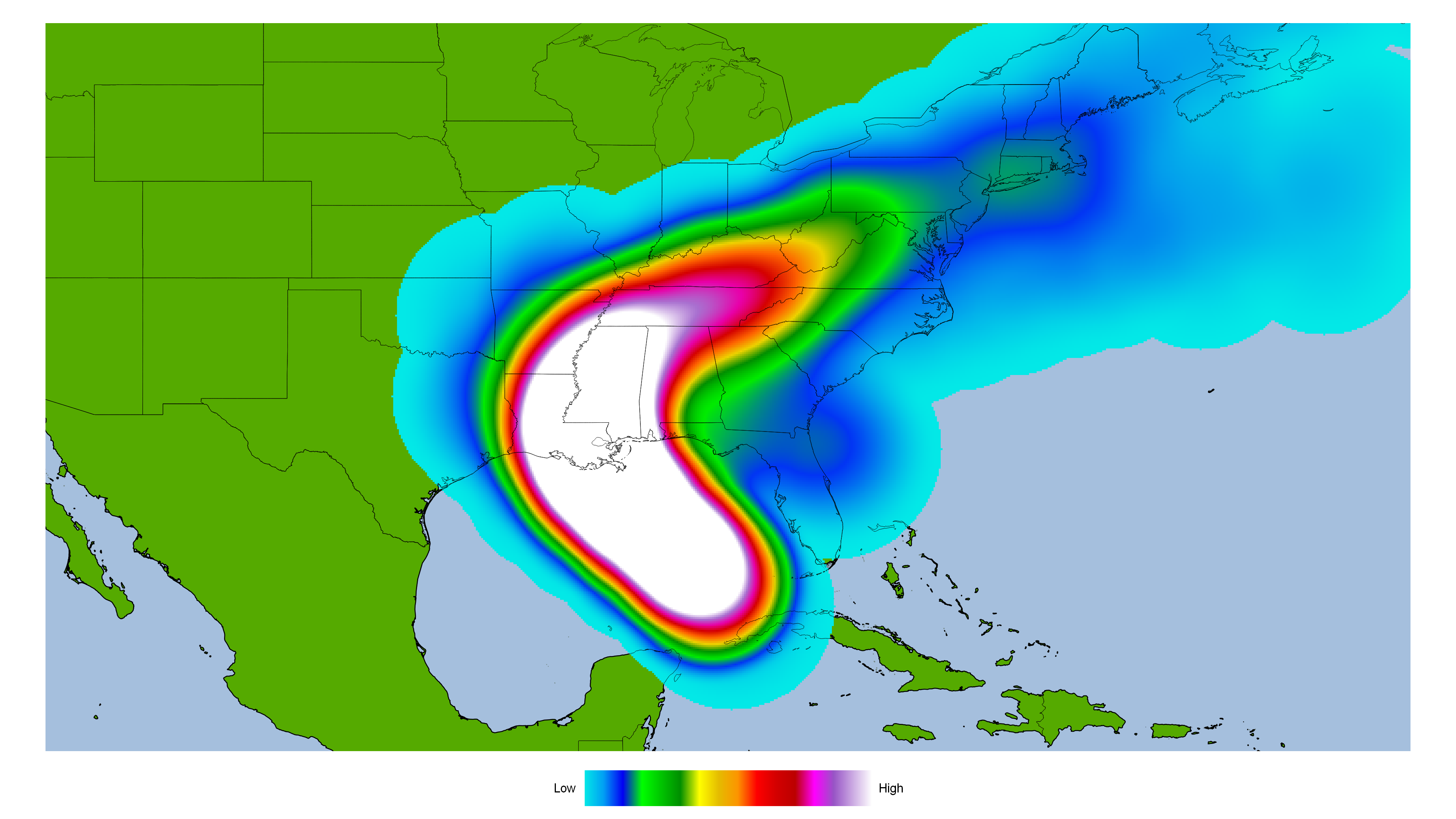
It is looking more likely Ida is going to make landfall somewhere between Louisiana, Mississippi, and Alabama. Texas and Florida are less likely to have Ida making landfall. The landfall risk includes New Orleans. New Orleans is mostly below sea level.
New Orleans was flooded out after Hurricane Katrina ravaged the Gulf Coast in 2005. New Orleans has pump stations to pump water out of the city. To make matters worse, some pump stations are out of service. Here is map of New Orleans pump stations that are online and offline. It is courtesy of The Times-Picayune and The New Orleans Advocate.

That would be a bad time if Ida is over them and the pumps are not fully online. If the dirty side of Ida is over New Orleans, there could be massive storm surge that floods the city. One area of concern is Lakeview, which is below sea level. Lakeview flooded after the levees failed from Hurricane Katrina. New Orleans area had 60 to 90 mph (96 to 144 km/h) winds with gusts of 90 to 135 mph (144 to 216 km/h) winds during Katrina. New Orleans area could have 100 to 120 mph (160 to 192 k/h) winds with gusts of 150 to 180 mph (240 to 270 km/h) from Ida.
Looking at satellite image, the circular shape of Ida suggests it is starting to intensify. Here is an intensity forecast model for Ida.

Most forecast models have Ida as a Category 3 within 24 hours. A couple have Ida peaking at Category 4 hurricane. Intensity forecast models are not reliable. I would not be surprised if Ida undergoes rapid intensification. Come morning, Ida is likely to be a Category 4 hurricane. I would not be surprised if Ida ends up being a Category 5 hurricane. Here is something that is unsettling. New Orleans is not going to issue mandatory evacuations and contraflows. As mentioned, New Orleans is vulnerable from flooding. Storm surge will certainly flood the city. Here is an excerpt from the article:
Hurricane Ida is approaching New Orleans more rapidly than city officials had initially prepared for, Mayor LaToya Cantrell said in an evening press conference Friday.
The storm, now projected to hit the Gulf Coast as a major Category 4 hurricane on Sunday, is moving so fast that the city will not be able to issue a mandatory evacuation for residents or implement contraflow for those evacuating voluntarily. New Orleans is expected to feel the effects of Ida as early as Saturday night.
“It is vitally important. We want our people to be in their safe spaces by, and no later than midnight tomorrow,” said Cantrell.
That is very unsettling to think about. If Ida was to flood New Orleans, the city is going to be cut off from the world. There maybe no power and water and this is on top of COVID-19 pandemic. Many New Orleans area hospitals have COVID patients and some are on life support. Evacuating them will be a logistical nightmare. Here is a dire warning for Hurricane Katrina on August 28, 2005. It could apply with Ida:
URGENT - WEATHER MESSAGE
NATIONAL WEATHER SERVICE NEW ORLEANS LA
1011 AM CDT SUN AUG 28 2005

...DEVASTATING DAMAGE EXPECTED...

.HURRICANE KATRINA...A MOST POWERFUL HURRICANE WITH UNPRECEDENTED
STRENGTH...RIVALING THE INTENSITY OF HURRICANE CAMILLE OF 1969.

MOST OF THE AREA WILL BE UNINHABITABLE FOR WEEKS...PERHAPS LONGER. AT
LEAST ONE HALF OF WELL CONSTRUCTED HOMES WILL HAVE ROOF AND WALL
FAILURE. ALL GABLED ROOFS WILL FAIL...LEAVING THOSE HOMES SEVERELY
DAMAGED OR DESTROYED.

THE MAJORITY OF INDUSTRIAL BUILDINGS WILL BECOME NON FUNCTIONAL.
PARTIAL TO COMPLETE WALL AND ROOF FAILURE IS EXPECTED. ALL WOOD
FRAMED LOW RISING APARTMENT BUILDINGS WILL BE DESTROYED. CONCRETE
BLOCK LOW RISE APARTMENTS WILL SUSTAIN MAJOR DAMAGE...INCLUDING SOME
WALL AND ROOF FAILURE.

HIGH RISE OFFICE AND APARTMENT BUILDINGS WILL SWAY DANGEROUSLY...A
FEW TO THE POINT OF TOTAL COLLAPSE. ALL WINDOWS WILL BLOW OUT.

AIRBORNE DEBRIS WILL BE WIDESPREAD...AND MAY INCLUDE HEAVY ITEMS SUCH
AS HOUSEHOLD APPLIANCES AND EVEN LIGHT VEHICLES. SPORT UTILITY
VEHICLES AND LIGHT TRUCKS WILL BE MOVED. THE BLOWN DEBRIS WILL CREATE
ADDITIONAL DESTRUCTION. PERSONS...PETS...AND LIVESTOCK EXPOSED TO THE
WINDS WILL FACE CERTAIN DEATH IF STRUCK.

POWER OUTAGES WILL LAST FOR WEEKS...AS MOST POWER POLES WILL BE DOWN
AND TRANSFORMERS DESTROYED. WATER SHORTAGES WILL MAKE HUMAN SUFFERING
INCREDIBLE BY MODERN STANDARDS.

THE VAST MAJORITY OF NATIVE TREES WILL BE SNAPPED OR UPROOTED. ONLY
THE HEARTIEST WILL REMAIN STANDING...BUT BE TOTALLY DEFOLIATED. FEW
CROPS WILL REMAIN. LIVESTOCK LEFT EXPOSED TO THE WINDS WILL BE
KILLED.

AN INLAND HURRICANE WIND WARNING IS ISSUED WHEN SUSTAINED WINDS NEAR
HURRICANE FORCE...OR FREQUENT GUSTS AT OR ABOVE HURRICANE FORCE...ARE
CERTAIN WITHIN THE NEXT 12 TO 24 HOURS.

ONCE TROPICAL STORM AND HURRICANE FORCE WINDS ONSET...DO NOT VENTURE
OUTSIDE!

$$
Reading that advisory from Katrina sends a chill down my spine. If Ida was to get close to New Orleans, it could be like Katrina again. Hopefully, that will not be the case.
I think Ida will be a major hurricane come morning. I would not be surprised if Ida is a Category 5 hurricane. Everyone along the Gulf Coast needs to be prepared right now. If you need to evacuate, please do so right now. It could be really bad.


