An original post from 2013 that is reposted and changed.
It has been 40 years ago at this very moment that Hurricane Alicia ravaged Southeast Texas, centered in the Houston metropolitan area. Hurricane Alicia came during the Cold War between America and Soviet Union. The Cold War ended in 1991 and underwent change. The world changed with 9/11 and COVID Pandemic.
The winter of 1982-1983 was an extremely strong El Nino. It was the strongest prior to winter of 1997-1998. It is one reason why 1983 Hurricane Season was inactive because the Pacific was coming off of a strong El Nino. There was a tornado outbreak in the early morning hours of May 20, 1983. It would be the last major tornado outbreak in the Houston area until November 21, 1992. Summer of 1983 was a wet one. In early August, an unusual cold front passes Southeast Texas, setting off thunderstorms as warm and moist air clashes with cool and drier air. Once the cold front is over the Gulf of Mexico, a mesoscale convective system (MCS) forms near the coast of Alabama and Mississippi on August 14th. A MCS is a large area of thunderstorms with a center of low pressure.
The area of thunderstorms continues to persist that a low pressure system forms on August 15th. By 7:00 AM CST, the area of thunderstorms became Tropical Depression 3. It is unusual to see a tropical cyclone development from a frontal boundary in August. It is more likely to do so early or late in the season because cold fronts usually do not go into the Gulf of Mexico. Later that day, Tropical Depression 3 became Tropical Storm Alicia with 50 mph winds. It was strengthening due to favorable conditions. Also, Alicia was a relatively small storm and was in an area of higher ambient pressure. Alicia was moving slowly to the west-northwest towards Texas.
On August 17th, Alicia becomes the first hurricane of the 1983 season. It is slowly moving south-southwest of Galveston. Galveston has been hit by hurricanes in the past. It is also where the deadliest hurricane and natural disaster in American history, the Great Galveston Hurricane of 1900. It made landfall southwest of Galveston on September 8, 1900. It claimed 12,000 lives, which is more lives lost than the 1906 San Francisco Earthquake (6,000), September 11, 2001 Terrorist Attacks (3,000), and Hurricane Katrina (1,836) combined.
What is Galveston doing to prepare for the onslaught of Alicia? They are ordering people to evacuate and take cover on high ground. They evacuate to avoid storm surge produced by the hurricane. Before hand, when the National Hurricane Center (NHC) were issuing gale warnings and they were not taken seriously. Galveston Mayor E. Gus Manuel ordered an evacuation on storm surge vulnerable areas. Conditions begin to worsen in Galveston. By midnight of August 18th, Mayor Manuel orders a mandatory evacuation, which is by than too late. Bridges are inaccessible due to deteriorating weather condition in Galveston.
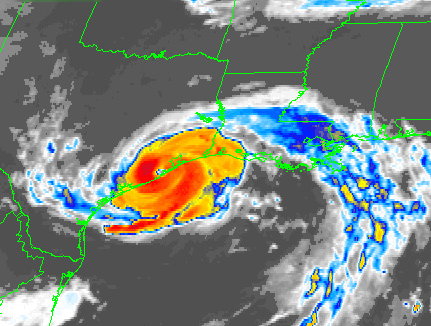
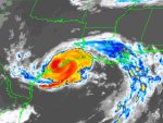
Alicia undergoes rapid intensification and becomes the first and only major hurricane of the 1983 season. It is getting ever so closer to Galveston. Waves are getting larger, storm surge is getting higher, wind is getting stronger, and rain is getting heavier. Alicia is getting close to make landfall. People who are trying to evacuate are realizing they made a huge mistake. Their complacency proved to be a decision they would regret. The last time, an evacuation was called was in August 1980 when Hurricane Allen was in the Gulf of Mexico. Allen was a Category 5 hurricane before it made landfall as a Category 3 hurricane in South Texas. Galvestonians thought they dodged a bullet again. They were proven very wrong. In some cases, it proved deadly.
A little after 1:00 AM, Alicia made landfall southwest of Galveston as a major hurricane. Galveston was getting hammered with strong winds, heavy rain, and storm surge. At landfall, Alicia was slightly larger than average. It had gale force winds extending up to 125 miles and hurricane force winds extending up to 60 miles from the eye. Alicia was not done with Texas. It was moving to the northwest towards the city of Houston. Everyone in Houston had hunkered down for Alicia. It was a very long night.

As Alicia moved further inland, it was weakening, but it did little to quell the fears of Houstonians. Houston was getting violently lashed by Alicia with heavy rain and strong winds. To make matter worse, tornadoes were spawned by Alicia. An area from Hobby Airport to Galveston were hammered by tornadoes. Power lines and transformers were getting blown away. Power outages were wide spread throughout the Houston area. By the time Alicia was over Downtown Houston, it had weakened to a borderline Tropical Storm/Category 1 hurricane. However, the winds were lashing Downtown Houston. The strong winds turned pebbles into bullets, which were on roofs of these at the time new skyscrapers. The pebbles damaged many windows on those downtown buildings. As Alicia progressed, it was weakening into a tropical storm and dumping heavy rain. There was widespread flooding in Southeast Texas from Alicia’s heavy rain. Many areas in the Houston area saw 6 to 10 inches of rain with isolated totals of 11 inches. This is flooding on top of storm surge that flooded coastal areas.

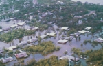
The next morning, people woke up to widespread damage from Alicia. Trees were knocked down, damaging houses, flooding streets, and no power. People are wondering what to do next, rebuild or not. To make matters worse, 21 people died from Alicia. All in all, Alicia did $2.6 billion dollars in damage, making it at the time, the most costliest hurricane in Texas. The name Alicia would be retired from the hurricane name list and be replaced with the name Allison.
Allison was first used in 1989 and it ravages Southeast Texas in the form of a tropical storm that dumps heavy rain. Also, it would ravage Central Louisiana, giving them record rainfall. However, that would not be the last time, Allison would visit Texas. In June of 2001, Tropical Storm Allison visits again and this time it proved to be catastrophic on June 8-9, 2001. Allison dumps extremely heavy rain over Houston and causes $5.5 billion in damages and claims 22 lives. As a result, Allison was retired and replaced with the name, Andrea.
Alicia would not be the last catastrophic hurricane to visit Houston-Galveston area. On September 13, 2008, Ike made landfall on Galveston. Ike was not as strong as Alicia in terms of wind, but was much larger, on the scale of Carla (1961) or Katrina (2005). Ike was extremely catastrophic for Texas and Louisiana, that it is the third most costliest hurricane, only Katrina and Sandy exceed Ike. 84 people in Texas lost their life from Ike and did a total of $37.5 billion in damages basin wide. Hurricane Harvey paid a visit to Texas in August 2017. Harvey dumped heavy rain over a large area. Many areas in Texas and Louisiana had 30 to 40 inches with amounts as high as 80 inches of rain! Harvey claimed a total of 103 lives and did $125 billion in damages. Harvey ties with Katrina as the costliest hurricane in America as of 2023.
NHC-Hurricane Alicia Preliminary Report
Committee On Natural Disasters Hurricane Alicia
Weather Prediction Center-Hurricane Alicia