Historic Hillary

Hurricane Hilary at 19.1°N – 112.4°W
https://www.star.nesdis.noaa.gov/goes/floater.php?stormid=EP092023#homePageLink

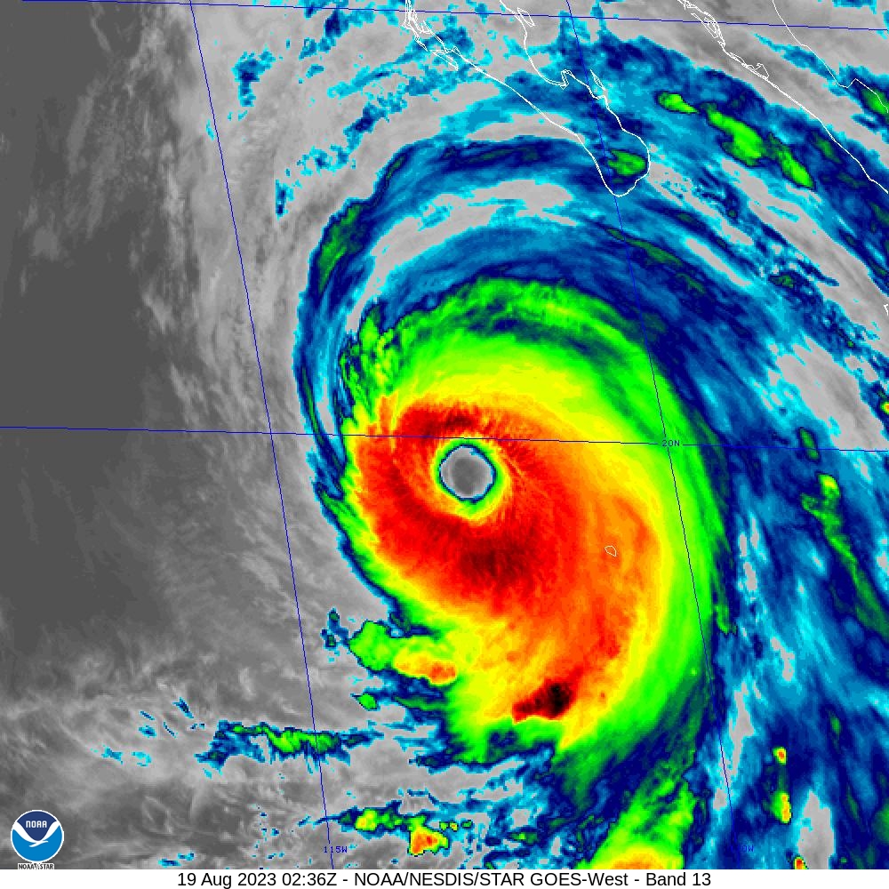
Hurricane Hillary is a monster hurricane as a Category 4 hurricane with 130 mph winds as of 10:00 PM CST. It is quite large for a East Pacific Hurricane as it it has tropical storm force winds extending up to 255 miles! Most East Pacific hurricanes are small as the basin is smaller than Atlantic or West Pacific. The East Pacific produces many hurricanes due to warm water, less dry air, and North American Monsoon. Monsoon spin up thunderstorm clouds. In fact, it is the second most active basin in the world. Only the West Pacific is most active. Typhoon is for West Pacific, which is west of the International Date Line.

Here is the most recent forecast model for where Hillary will go. The forecast model is from National Center for Atmospheric Research (NCAR). It is a heat map generated by QGIS. The heat map use points within 300 mile/480 kilometers radius. I used the latest forecast, which is at 0000Z.

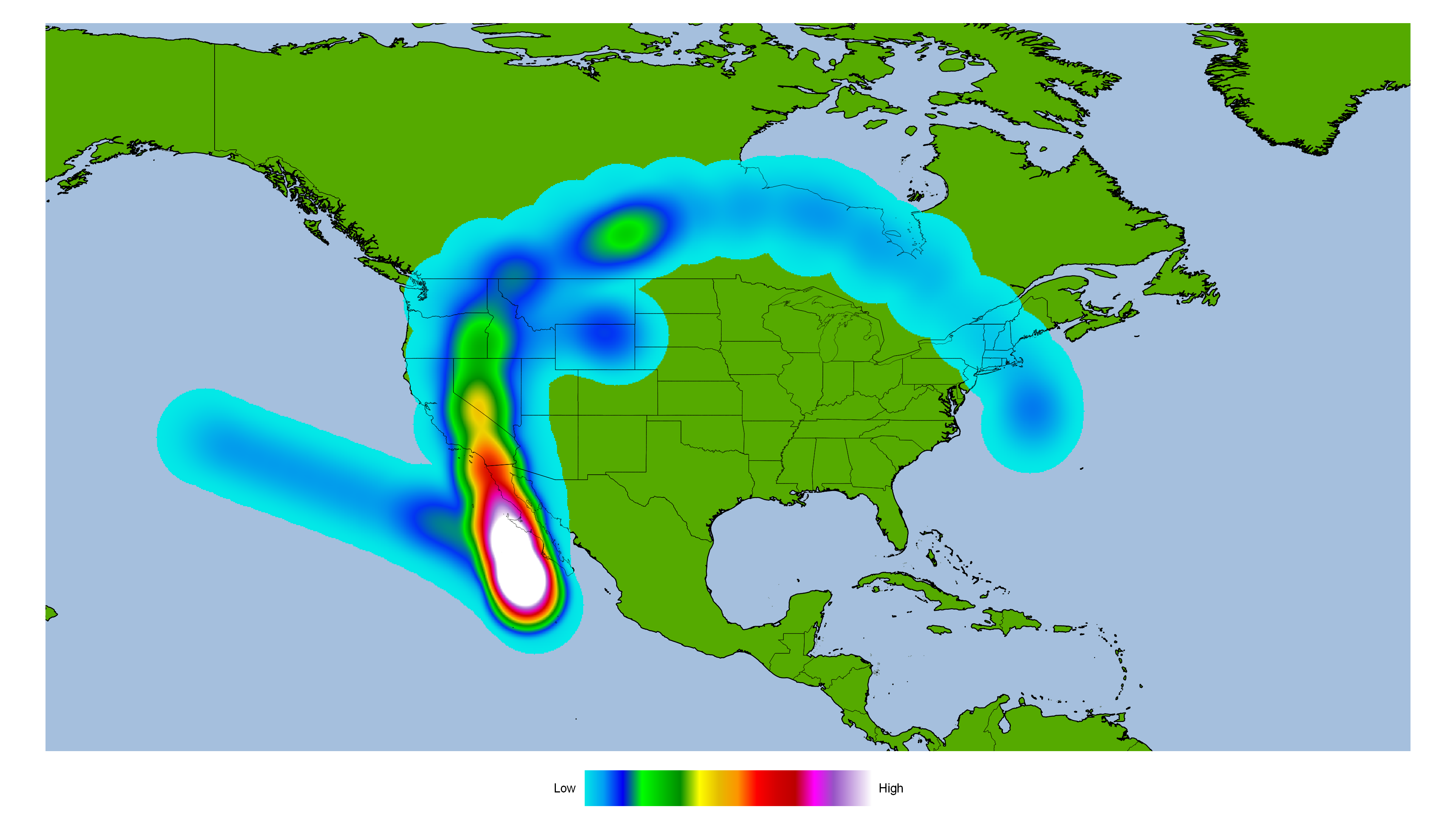
Most of the forecast models have Hillary heading northwards towards Baja California. From there, it could remain over Baja California or stay over the ocean and head towards Southern California. How intense will Hillary be by the time it comes close to Southern California? Here is an intensity forecast model from NCAR.

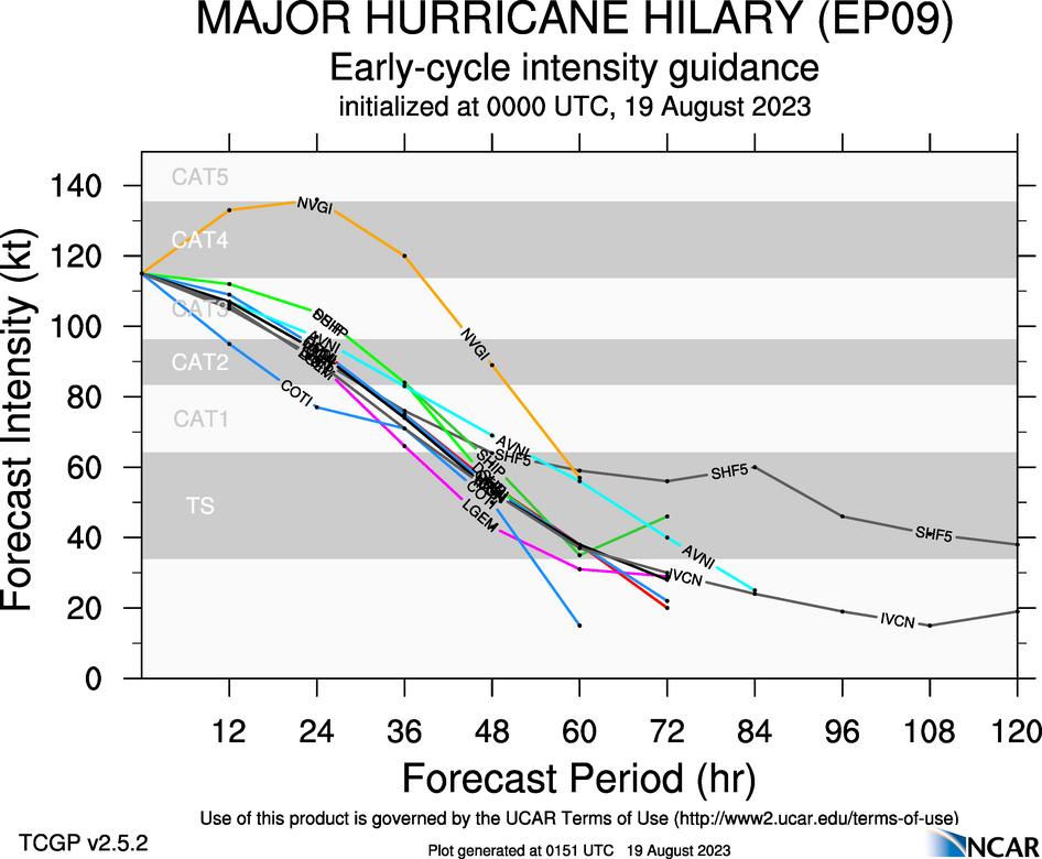
Most forecast models have Hillary weakening in 24 hours. The NVGI has it intensifying further. I would not be surprised if Hillary does intensify further. I think Hillary is most likely to weaken further. Most forecast models have Hillary as a tropical storm before it hits Southern California.

Tropical cyclones have hit Southern California in the past. It last happened in 1939, when it made landfall around Long Beach. It has been dubbed “El Cordonazo” or “The Lash of St Francis”, which is named by Mexican fishermen. The once hurricane dumped heavy rain over large area of Southern California. Some areas saw nearly a foot of rain. The storm claimed nearly 100 lives. San Diego was hit by a hurricane in 1858. The only recorded hurricane to hit California. It is very likely California has been hit by hurricanes prior to 1858. It reportedly dump heavy rain over a large area of Southern California. Both occurred during El Nino. East Pacific is more active during El Nino.

Tropical cyclones rarely hit California because the water is cooler, compared to the East Coast or Gulf Coast. Tropical cyclone remnants have impacted California and the American Southwest. They often provide beneficial rains.

Here are rainfall forecast totals between August 18, 2023 to August 28, 2023. They are from Weather.US. The forecast models are:
GFS (American)
EURO (European)
GDAPS/UM (South Korea)
JMA (Japanese)
GEM (Canadian)
CMA (China)

GFS (American)
EURO (European)
GDAPS/UM (South Korea)
JMA (Japanese)
GEM (Canadian)
CMA (China)

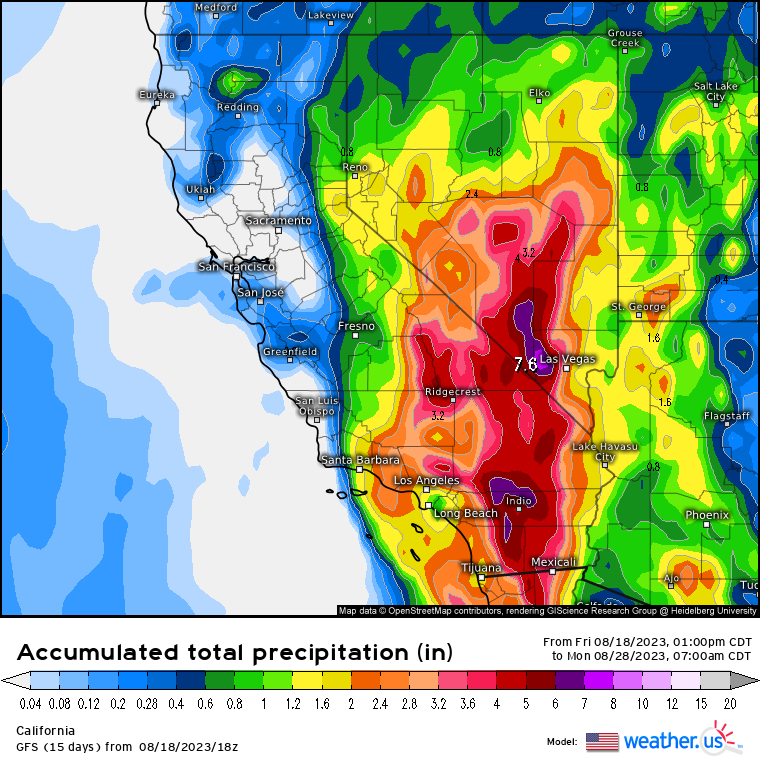
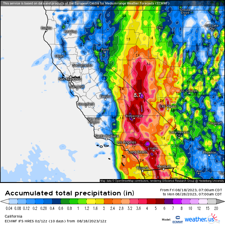
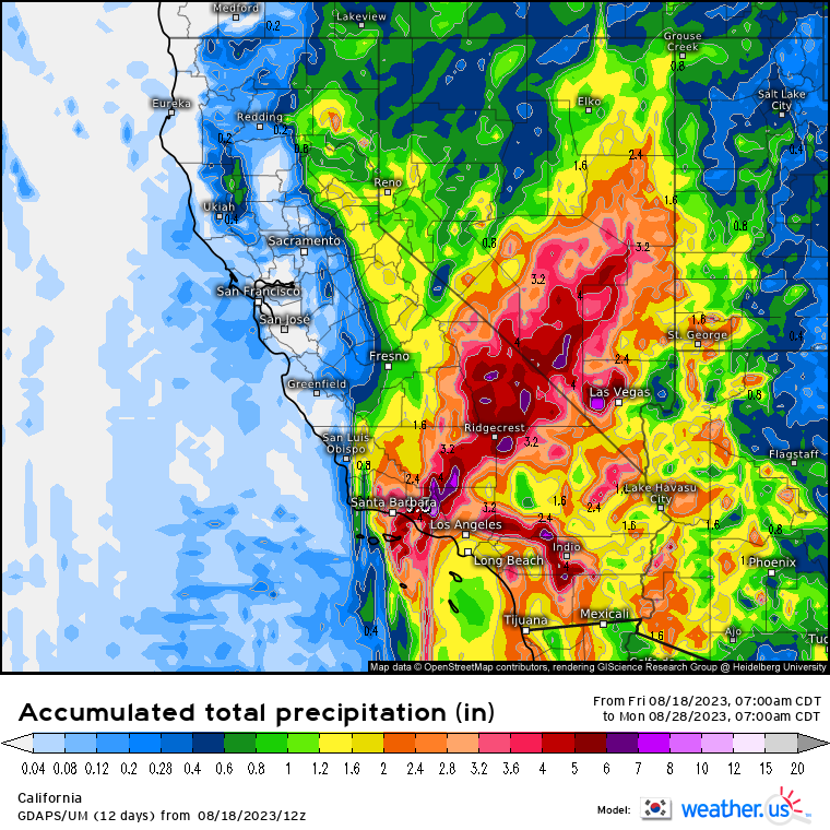
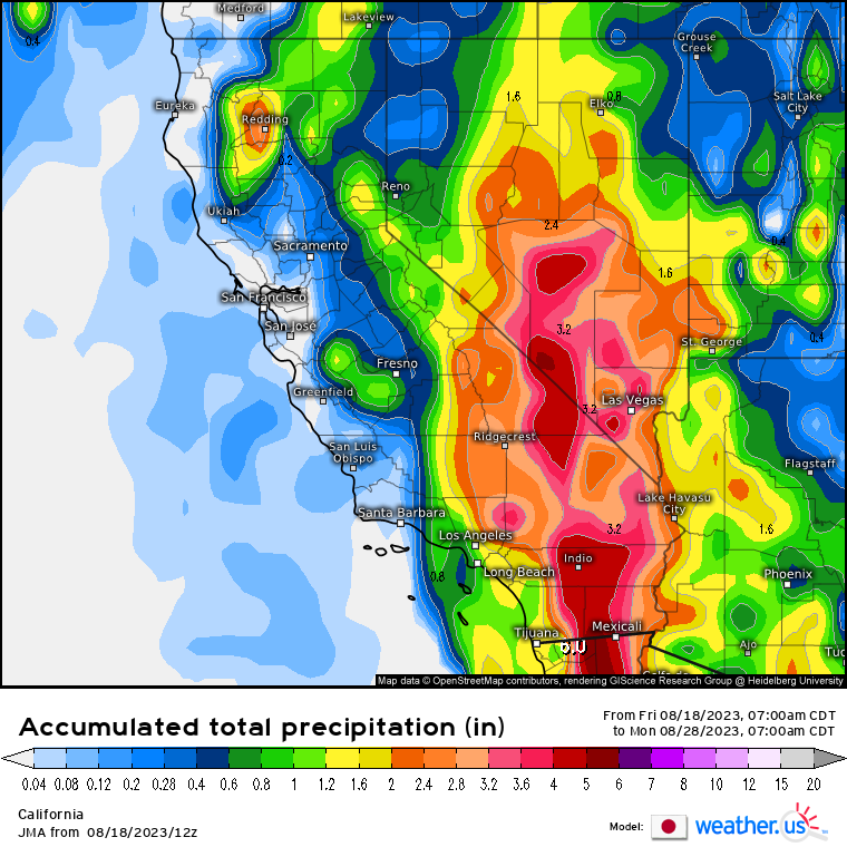
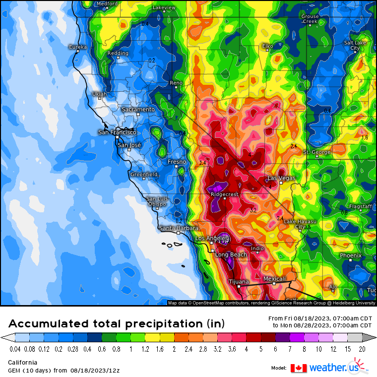
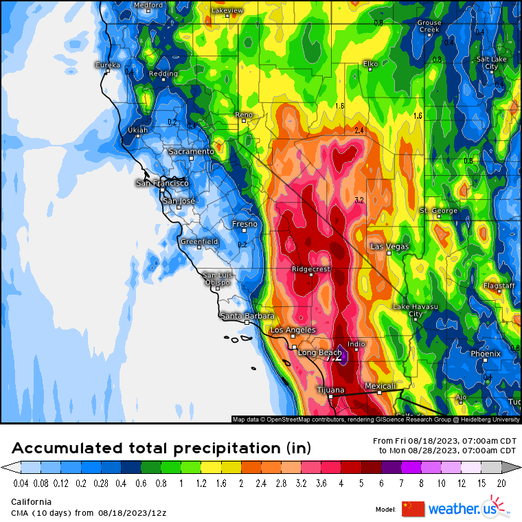
The Canadian has the highest amount of 11.00 inches of rain. The Japanese has the lowest amount of 6.00 inches. I ran a statistical analysis using PSPP. I look at rainfall total forecast.

Mean8.38
Median8.15
Standard Deviation1.82
95% Confidence Interval Lower Bound6.47
95% Confidence Interval Upper Bound10.30

The mean rainfall total is 8.38 inches with median of 8.15 inches. The 95% Confidence Interval range are from 6.47 inches to 10.30 inches. It is probable the rainfall total will be somewhere between 7 to 11 inches of rain. There is a five percent chance that it is not in the true mean. It means it could be below 7 inches or over 11 inches. I can say with 95% confidence that the rainfall total is probably going to be somewhere between 7 to 11 inches of rain. More than likely, it is over 7 inches of rain.

I would not be surprised if some areas see over a foot rain. It would mostly likely be in the mountainous areas of California and Arizona. Mountainous areas on windward side are very wet. In fact, some of the wettest areas in the world are in mountainous areas.

Here is what I think will happen.
-Hillary is likely to weaken overnight.
-Hillary could make landfall on Baja California.
-Hillary is likely to make landfall as a tropical storm on Southern California.

Invest 91L As This Weekend’s Rainmaker?

Invest 91L is over the Gulf of Mexico. Currently on satellite from CIMSS-Tropical Cyclones, it does not look too impressive.

Of course with tropical lows, they tend to fire up at night as they are warmer than the surrounding area. I would not be surprised to see a lot of thunderstorms come morning. As the time passes, where does Invest 91L go?

Most forecast models have it going towards South Texas or Mexico. There is a chance that it could go over Southeast Texas. If it goes into Mexico or South Texas, there is better chance for rain since the northeast side is the wettest as it is the “dirty” side of the tropical low. The intensity forecast models are split.

Some have Invest 91L as a tropical wave. Some have it intensifying into a tropical depression. Some have it becoming a tropical storm. If it becomes a tropical storm, it would be Beryl. Like I say, intensity forecast is not really reliable. At this point, I would be more concerned with the rain than some tropical storm developing.

Various forecast models have different rain amounts, which are from GFS, Canadian, EURO, and Weather Prediction Center (WPC). They are from Weather.US and Weather Prediction Center (WPC)-Quantitative Precipitation Forecasts (QPF). These are 7 day rainfall totals.

The GFS has the heaviest rain over Houston area. It forecasts up to 8 inches of rain. A large area of Southeast Texas has 3 to 6 inches of rain.

The Canadian forecasts rain amounts of up to 6 inches over Austin area and around Halletsville.

The EURO forcasts up to 20 inches of rain southeast of San Antonio. There is 10 inches south of Houston. The EURO is the wettest of the forecast models.

The WPC has up to 5 inches of rain over Southeast Texas. It is the driest of the forecast models.

All the forecast models have rain for Texas. The only difference is the amount. Some are very bullish, while others are not. The plus side is that it will put a dent on the drought in Texas.

Most areas in Texas are in a drought. The rains can alleviate the drought, which is a good thing. This also increases the risk for flooding, which is not good almost a year after Harvey ravaged Texas with epic rainfall.

I think Invest 91L will be more of a rain event this weekend. Tropical development is not likely, but cannot be ruled out. Regardless, Invest 91L needs to be watched as it could be more of a rain event that may cause flooding in some areas.

The forecast models came from NCAR-Tropical Cyclone Guidance. The GIS drought map is from United States Drought Monitor.

A Weakening Bud And Invest 91L

Oh how the mighty have fallen! Yesterday, Bud was a hurricane. Today it is a tropical storm with 50 mph 44 knots 80 km/h winds. It was once a formidable Category 3 hurricane. All the forecast models have Bud weakening.

With Bud running into cooler water and closer to land, it is most likely to weaken. The next important question is where Bud goes.

The forecast models are having Bud moving towards Baja California and the Southwestern US as a low pressure system. The moisture from Bud is certainly welcomed in the Southwest as they are very dry.

Almost the entire Four Corners is engulfed in a severe drought. It centers around where the Four Corners meet. There is also a severe drought in the Texas Panhandle region. Any rain is welcomed regardless. This leads to Invest 91L in the Caribbean. Many are asking where 91L will go.

Most of the forecast models have Invest 91L heading towards either Mexico or Deep South Texas. Some have it heading towards Southeast Texas. Regardless of where 91L goes, rain will be the main issue. Since Invest 91L is over an area of warm water, does it have a chance of developing?

Most forecast models have 91L at tropical wave or tropical depression. One has it as a tropical storm. Again, it is too early to tell if it will develop. Tropical waves or low pressure areas in the Caribbean and Gulf of Mexico can form suddenly into a tropical storm or even hurricane. It has happened many times in the past. I am not suggesting it will happen with 91L. It is something to consider.

The Tropical Cyclone Formation Probability Guidance Product does give Invest 91L a chance of developing into a tropical cyclone in the next 48 hours. Again, that is only a small chance of developing.

Since, we are on the topic of tropical weather trouble, it brings rain. Various forecast models have different rain amounts, which are from GFS, Canadian, EURO, and Weather Prediction Center (WPC). They are from Weather.US and Weather Prediction Center (WPC)-Quantitative Precipitation Forecasts (QPF). These are 7 day rainfall totals.

The GFS has less rain for Texas and the Southwest. Southeast Texas has 2 to 4 inches of rain. The Southwest sees 0.50 to 2 inches of rain with 6 inches in the mountains.

The Canadian is not particularly generous for the Southwest. However for Southeast, Texas it has up to 8 inches of rain.

The EURO is generous for Southwest and Texas. The mountains of Arizona, New Mexico, and Colorado have up 8 inches of rain. Most of Arizona is wet as well compared to GFS and Canadian.

The WPC has 2 to 4 inches of rain over Southeast Texas. The Southwest has 0.50 to 1 inches of rain with isolated areas seeing 2 inches of rain.

The forecast models are unanimous on that rain will fall in Texas and the Southwest. They diverge on rain amount. Some forecast lesser amounts, while others forecast higher amounts. We should have a better idea of rain amounts later on.

My take on this. Invest 91L is more likely going to be a rain event. I do not expect 91L will develop at this point, but of course anything can happen. I do not think we will see another Harvey event from 91L. It is not forecasted to linger over Texas, like what Harvey or Allison did. As for Bud, the Southwestern US should welcome the rain with open arms. They will need it for sure.

The forecast models came from NCAR-Tropical Cyclone Guidance. The GIS drought map is from United States Drought Monitor.

Hurricane Bud And Invest 91L

NOAA/NESDIS/STAR GOES-16 ABI BAND 11 OR_ABI-L1b-RadF-M3C11_G16_s20181640230401_e20181640241168_c20181640241232.nc

It is June and the tropics are heating up. We have two areas of interests, Hurricane Bud in the East Pacific and Invest 91L in the Caribbean. Let’s start with Bud.

Hurricane Bud was a powerful Category 3 hurricane that weakened into a Category 2 hurricane with 100 mph 85 knots 161 km/h winds. It is due to cooler water Bud is encountering. Cooler water tends to weaken hurricanes even if there is not a whole of wind shear.

The area of warm water in the East Pacific is not that great. However, two major hurricanes have formed so far, which are Aletta and Bud. East Pacific is one of the most active basins despite its small size. As Bud weakens, where does it go? Here is a heat map forecast for Bud.

Most forecast models have Bud heading towards Baja California later by the end of the week. Where it goes after looks to be heading towards the Southwest. They can certainly use the rainfall as they are in a severe drought. The next question is how strong will Bud be?

Most forecast models have Bud as a tropical storm with one as a Category 1 hurricane around the time it us close to Baja California. From there, it is forecasted to weaken to a tropical depression.

The next problem is closer to home, Invest 91L. It is located off the coast of Honduras in the Caribbean. It is right now just a tropical wave with a cluster of thunderstorms. Many are wondering where will 91L will go? Here is a heat map forecast for 91L.

Most of the forecast models have 91L heading towards the Western Gulf of Mexico. One has it heading towards Florida looping around. It is just one forecast model. The forecast models at this time are heading towards Texas. Since this is a tropical wave, the forecast model is subject to change. The $64,000 question is will 91L become a tropical storm or hurricane, which would be Beryl.

Most forecast models keep 91L at tropical depression. Only one has a tropical storm at this time. Intensity forecast models are unreliable, especially if nothing has developed yet. Some factors do favor development. Let’s look at the water around Invest 91L.

The depth of warm water in Caribbean and Gulf of Mexico is great and over a large area. The heat potential is fairly high in the Gulf of Mexico and Caribbean. Warm water is certainly a factor in tropical development, but not the only one.

Wind shear over the Gulf of Mexico is within average and looks to be trending downward. Less wind shear is more favorable for tropical development. If there is strong wind shear over warm water, tropical development is greatly reduced as they blow tops of thunderstorm clouds that forming into something tropical.

At this time, I do not think Invest 91L will develop. It looks to be more of a rainmaker. However, anything can change between now and the end of the week.

The forecast models came from NCAR-Tropical Cyclone Guidance. The tropical heat came from A href=http://www.aoml.noaa.gov/phod/cyclone/data/go.html>Tropical Cyclone Heat Potential (TCHP). Wind shear map came from Tropical Cyclone Formation Probability Guidance Product.

Tropical Storm Franklin For 8/9/2017 1900 CDT

The first hurricane of the season, Franklin, is getting ever closer to Mexico. It looks to be that way.

Franklin is a Category 1 hurricane with 75 mph 120 km/h 65 knots wind. It has gusts of 94 mph 150.4 km/h 82 knots. Further intensification is possible as shown in the forecast model. Two models keep Franklin as a hurricane despite being over the mountains of Mexico. I am not convinced that will happen as the mountains tend to weaken hurricanes.

I would not be surprised if Franklin becomes a Category 2 hurricane with 105 mph 168 km/h 90 knots wind right before landfall as looks to be intensifying further. Franklin is an average sized hurricane. Tropical storm force winds extend up to 140 miles 224 km/h 122 nautical miles. Hurricane force winds extend up to 35 miles 56 km/h 30 nautical miles. from the eye.

Most areas in Mexico will see at most tropical storm force winds with hurricane force winds. Hurricane force winds should be most likely confined to the coast. Here is a probability map of hurricane force winds.

If Franklin makes landfall as a 85 mph 136 km/h 74 knots hurricane, the strongest wind possible is 72 mph 115 km/h 63 knots with gusts as high as 108 mph 173 km/h 94 knots. I determine this by multiplying the strongest winds by 0.85. Land reduces wind by 15 percent. However, due to friction, gusts are higher as I multiply sustained winds by 1.5.

My main concern is heavy rain from Franklin. Franklin is moving as 12 mph, which means it can dump about 8 inches (20.32 centimeters) of rain. Many areas are likely to see 4 to 10 inches (10.16 to 25.4 centimeters) of rain. Mountains areas could see as much as 20 inches (50.8 centimeters) of rain. This amount is certainly going to lead to flooding that can be deadly.

Patricia And The Floods

20151023_VIIRS_I-Band5_Patricia20E_0523EDT

Hurricane Patricia underwent explosive intensification from a Category 1 to Category 5 hurricane in 24 hours. It went from 980 millibars to 879 millibars! That is the most rapid intensifying hurricane in the Western Hemisphere! To make matters worse, it has 200 mph wind! That is much stronger than Atlantic’s most intense hurricane, Wilma in 2005. To put that in perspective, Wilma peaked at 882 millibars. Patricia is about to barrel towards Mexico as a full blown Category 5 monster.

However, with any intense hurricanes, they tend to fluctuate in strength due to eyewall replacement cycle and wind shear. By the time Patricia makes landfall on Mexico, it has a central pressure of 920 millibars and 165 mph winds. On land that would be 141 mph due to a 15 percent reduction from friction. However, the friction increases the gust by a factor of 1.5, which would be 210 mph! A weather station in Chamela-Cuixmala Biosphere Reserve recorded 185 mph winds with gusts as high as 211 mph, which suggests the station got damaged. 185 mph sustained winds on land is 278 mph! That would be a nightmare anywhere! Think of that in a major city like Houston, New Orleans, Miami, or New York. It turns out that Patricia made landfall on Cuixmala, Jalisco, Mexico, which is between Manzanillo and Puerto Vallarta. Mostly small villages and towns were affected by Patricia’s strong winds. Also, people evacuated from the coast as storm surge is possible. The death toll at this writing is 13. Pretty low for a potentially catastrophic hurricane.

Patricia was an average sized hurricane. East Pacific hurricanes tend to be smaller than Atlantic hurricanes due to a smaller basin area compared to the Atlantic. At peak and landfall, hurricane force winds were 50 miles in diameter. In comparison, Hurricane Ike before it hit Southeast Texas had hurricane force winds of over 200 miles in diameter! Smaller sized hurricanes produce smaller storm surge. Larger sized hurricanes produce larger storm surge. One reason why Ike and Sandy were so bad despite not being strong like Patricia was their large size. Interesting to note that Katrina made landfall on the Mississippi Delta as a Category 3 hurricane with central pressure of 920 millibars. The reason for that is Katrina is a large hurricane like Ike.

So, what allowed Patricia to undergo explosive intensification?

It had large area of warm water. This is due to a strong El Nino and warm Pacific Decadal Oscillation (PDO).

20151022-23_SSTAnomaly_NA

There was a large area of Precipitable Water (PW) over the Pacific near Mexico. The values are easily over 2 inches.

20151022-23_850mb_PrecipitableWater_NA

The relative humidity was very humid. This is relative humidity at 10,000 feet or 700 millibar level. That is more favorable for tropical development. Dry air kills tropical development.

20151022-23_700mb_RelativeHumidityAnomaly_NA

As all strong hurricanes, they must weaken and in this case, the Sierra Madre Occidental sheared it apart. Mountains are deadly for hurricanes as they can cut through their circulation. Yet, mountainous areas see higher winds and heavier rain, especially on the windward side. Once Patricia is reduced to a tropical low, the moisture from it dumps heavy rain over Texas. The heavy rain affects a large area of Texas. The heavy rain is from a slow moving Pacific front and Gulf of Mexico and Pacific moisture.

North Texas sees some of the heaviest rain. Corsicana, Texas go hammered with the heaviest rain. Powell saw over 20 inches of rain in 24 hours! Southeast Texas saw widespread heavy rain with flooding. Many areas saw 5 to 10 inches of rain. Some areas saw over 12 inches of rain.

20151026_7Day_Rainfall_Total

Here is a GIS map I created from AHPS and US Drought Monitor. Notice the heaviest rains is around Corsicana. In the 7 days, many areas saw over 8 inches of rain with totals as high as 15 inches of rain. The rains are beneficial as Texas is in a severe drought. Corsicana and Dallas/Fort Worth Metroplex were in the severe drought. I expect they will be out of the drought by this week according to US Drought Monitor.