
https://www.star.nesdis.noaa.gov/GOES/floater.php?stormid=AL102023#tab2
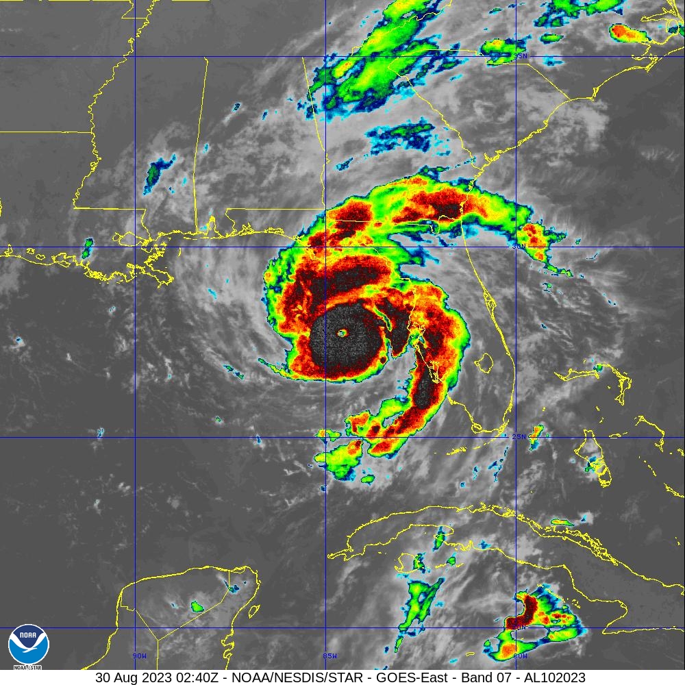
Hurricane Franklin is the first major hurricane of the 2023 Atlantic Season. It is a Category 3 hurricane with 115 mph winds as of 11:00 PM AST per National Hurricane Center (NHC). It peaked as a Category 4 hurricane. However, it is over the open Atlantic and poses little threat at this time. Right now, my main concern is Hurricane Idalia. It is a Category 2 hurricane with 110 mph winds as of 11:00 PM EDT. However, looking at satellite images, there is a tiny eye and circular shape suggests it is likely intensifying. Here is the intensity forecast model from National Center for Atmospheric Research (NCAR).

Most forecast models have Idalia as a Category 3 hurricane with one as a Category 4 hurricane. I consider intensity forecast models unreliable. I think Idalia is going to be a Category 4 hurricane by morning. It may even be a Category 5 hurricane. The water is quite warm. Here is a Maximum Potential Hurricane Intensity for the Gulf of Mexico. It is courtesy of Center for Ocean-Land-Atmosphere (COLA).
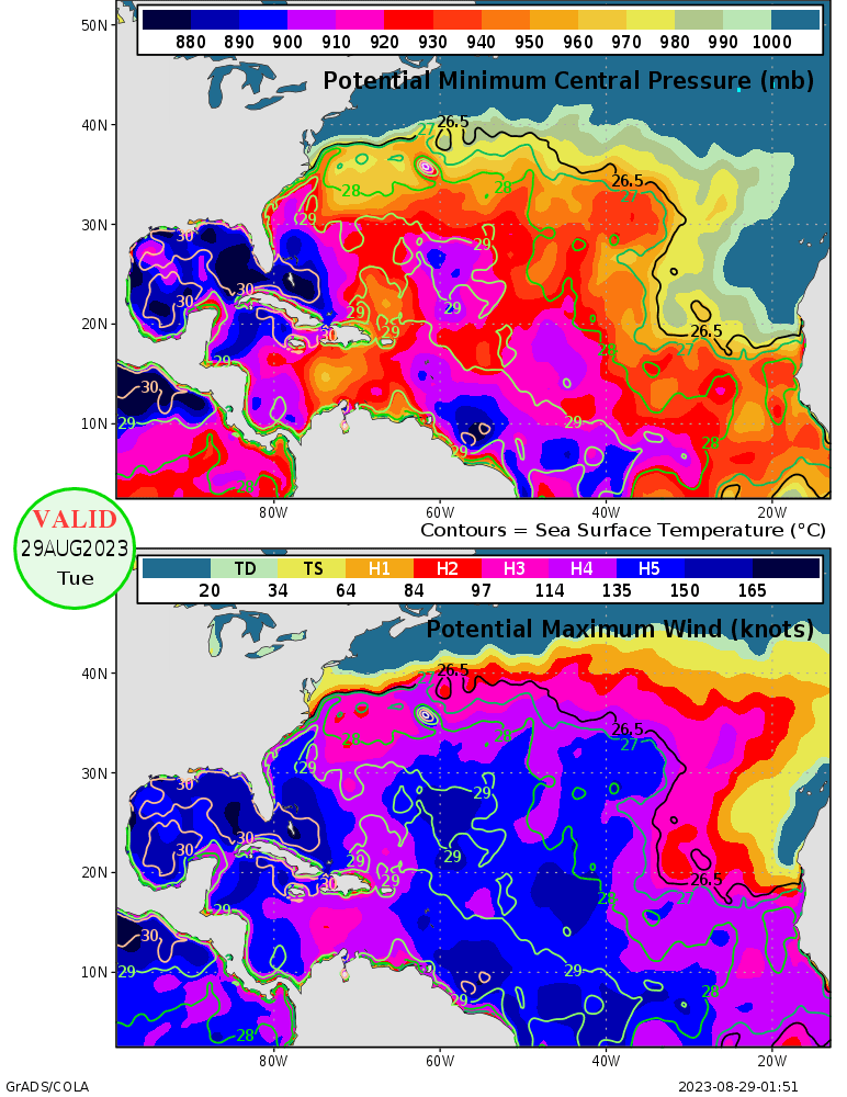
Idalia is over water that could support 880 millibars and winds of over 175 mph (150 knots). It does have the potential to be a Category 5 hurricane if conditions are right. I am most inclined to predict that Idalia will be a Category 4 hurricane with 150 mph winds. The most pressing is where Idalia will make landfall. The forecast model is from National Center for Atmospheric Research (NCAR). It is a heat map generated by QGIS. The heat map use points within 300 mile/480 kilometers radius. I used the latest forecast, which is at 0000Z.
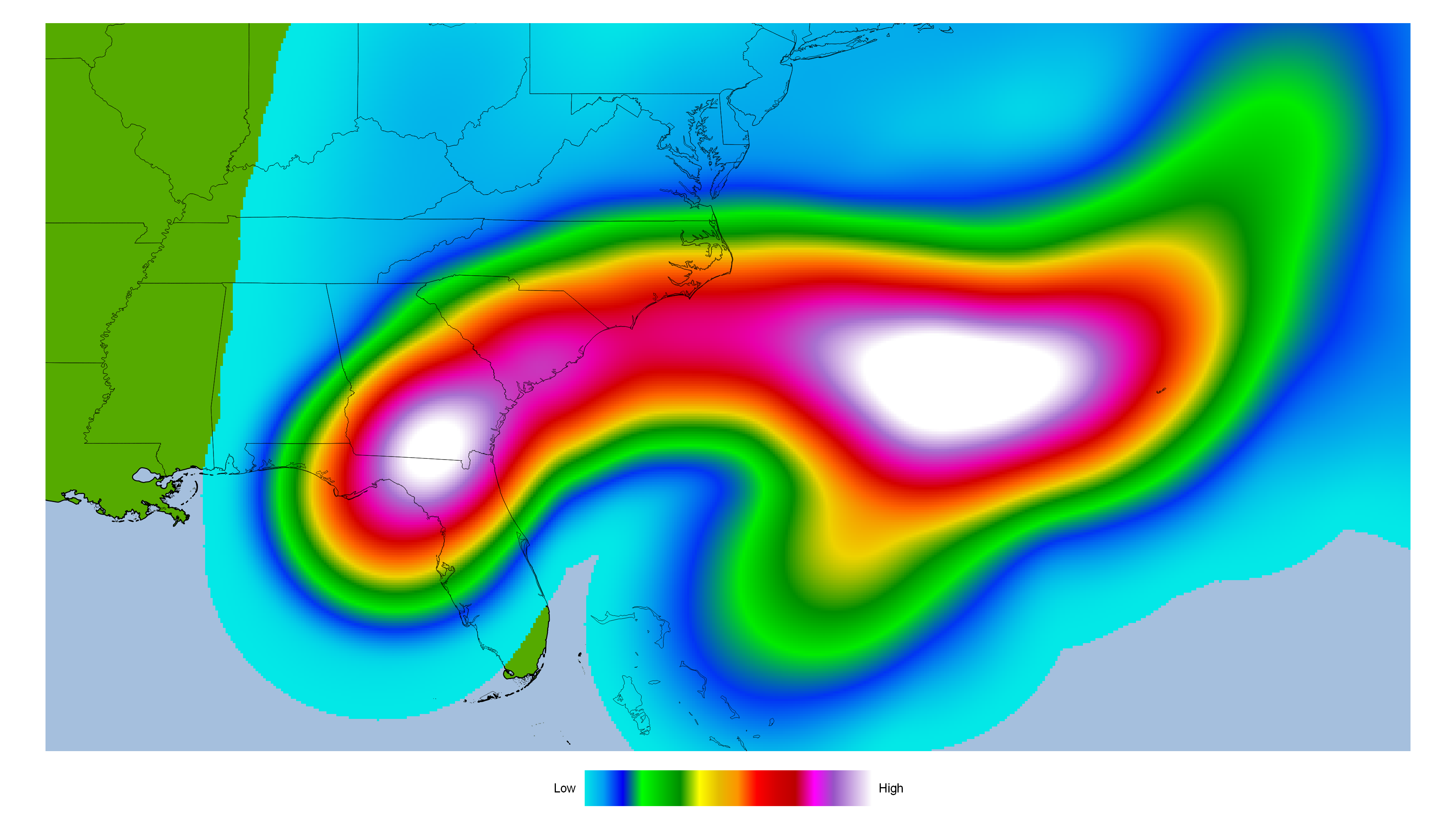
Most forecast models have Idalia heading towards the Big Bend of Florida. Big Bend is prone to storm surge due to large area of shallow water and shape of a funnel. Bays are vulnerable to storm surge as they have shallow water and funnel shape. Think Gavleston or Tampa Bay, which is one of the high risk area for storm surge. New Orleans, Houston, New York City, and Bangladesh are high risk for storm surge. Here is a storm surge map from the NHC. It is a potential storm surge flooding map.
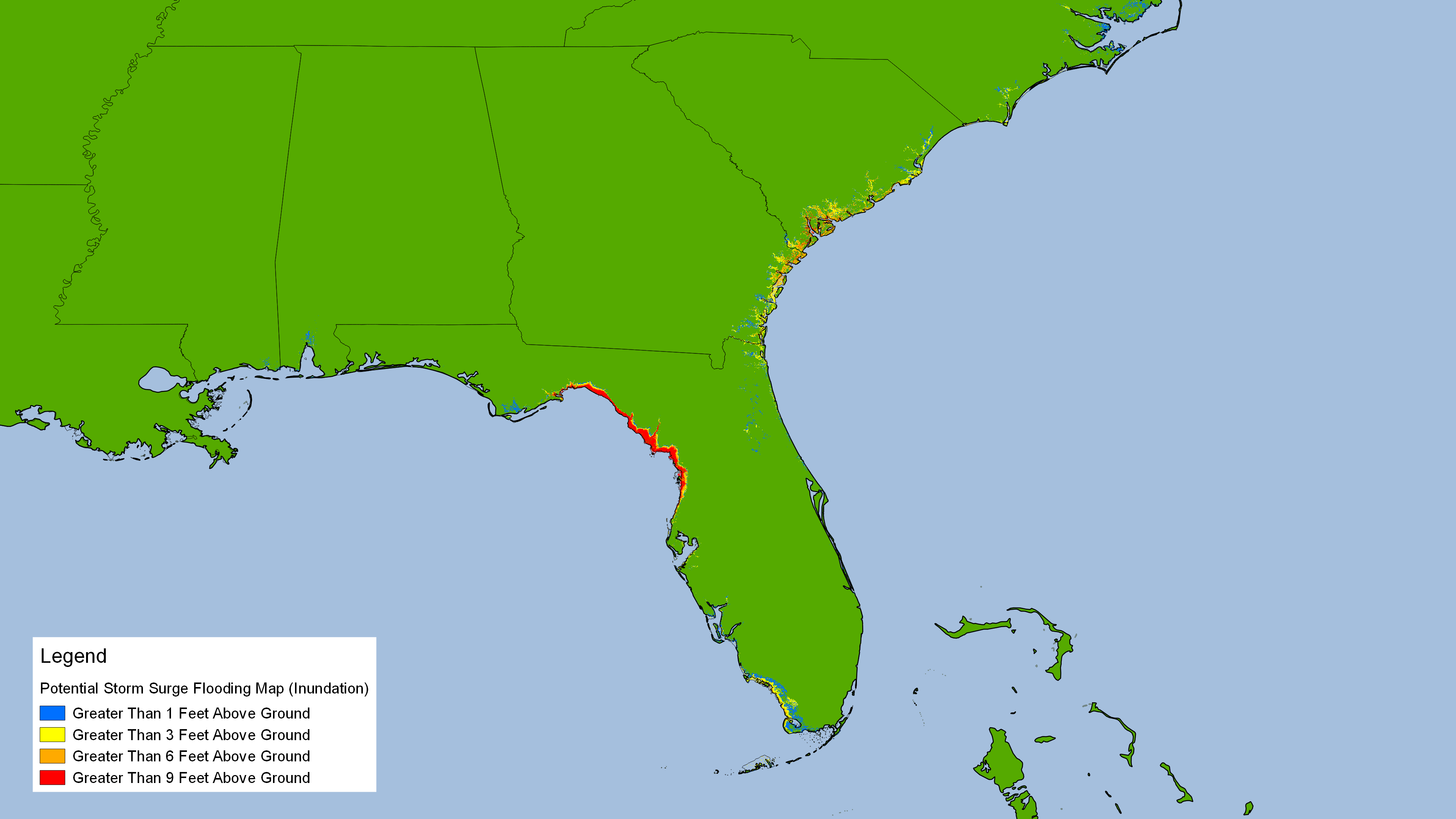
Some areas could see up to 15 feet storm surge, which is quite high. It could flood land areas with over 9 feet of water. That is dangerous storm surge. Anyone in the storm surge area should evacuate. Another factor for storm surge is size of storm and forward speed. Idalia is moving at 18 mph, which is rather fast. The speed could prevent Idalia from becoming a Category 5 hurricane. It is also a smaller hurricane. Here is a map wind radii for Idalia from NHC.
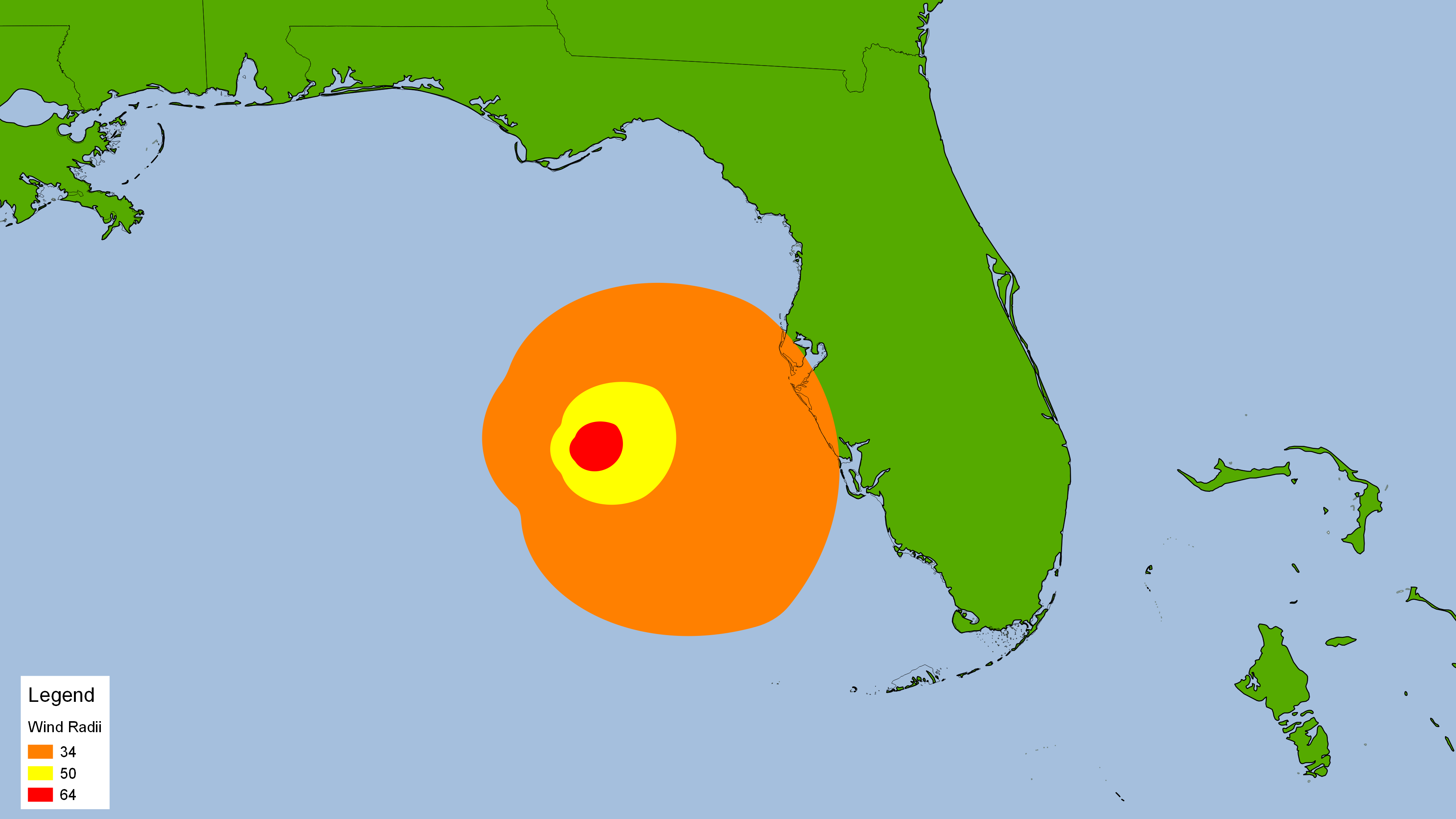
Tropical storm force winds extend up to 160 miles. Hurricane force winds extend up to 25 miles from the eye. Parts of Florida are already dealing with tropical storm force wind. The smaller size and relative fast speed of Idalia could make it less of a storm surge threat. Regardless, storm surge will be a dangerous threat for Florida.
Hurricane Idalia is going to be a dangerous hurricane. Anyone in storm surge area should of evacuated by now. Anyone inland should hide from the wind. It is going to be a rough ride.
Here is what I think will happen.
-Idalia will likely be Category 4 or 5 hurricane by morning.
-Idalia will likely make landfall on Florida by morning and near peak.
-Mostly will be a storm surge and wind event.
