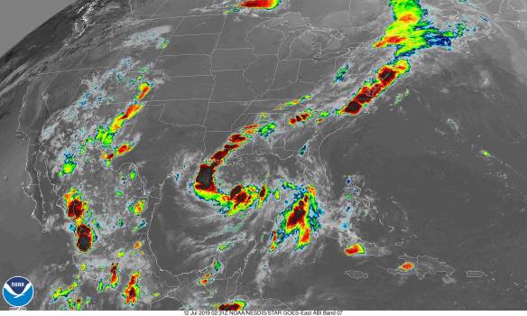
Tropical Storm Barry is currently over the Gulf Of Mexico. It is a poorly organized storm from the latest satellite image. There are multiple vortices in the storm, which makes forecasting a challenge.
The $64,000 question is where does Barry go. I created a heat map with mix of the latest forecast, which is 0000Z and 1800Z GFS ensemble track guidance. I got them from NCAR-Tropical Cyclone Guidance. It is a heat map using points within 300 mile/480 kilometers radius.
Most forecast models have it going into Louisiana. However, there is a westward trend from yesterday at this time. Here is yesterday’s forecast model for comparison.
The risk for Texas has gone up slightly. Despite most forecast models having Barry going into Louisiana, I am not going to say where the storm makes landfall as there are multiple vortices in Barry. Depending on which vortices wins out, it can change where Barry goes. Louisiana and Texas need to keep an eye on Barry.
The National Hurricane Center (NHC) forecasts it will become a strong tropical storm. Here is an intensity forecast model. It is also from NCAR-Tropical Cyclone Guidance.
Most forecast models have strong tropical storm. None forecast a hurricane. Like I have said many times, intensity forecast models are notoriously unreliable. If Barry gets stronger, it would move west towards Texas as hurricanes are more influenced by upper air pattern. I would not be surprised if Barry becomes a hurricane. I would forecast at most a Category 1 hurricane.
Here is what I think will happen.
-Depending on which vortices wins out, it can change where Barry goes.
-Hurricane is possible with Barry.
-Regardless of development, heavy rain and flooding will be the main problem.
Regardless of forecast, everyone should keep an eye on soon to be Barry.


